Cartes IGN - Hiking maps & guides
Explore French landscapes with detailed maps and GPS tracking features.
- 3.3.32 Version
- 1.2 Score
- 942K+ Downloads
- Free License
- 3+ Content Rating


Introducing Cartes IGN
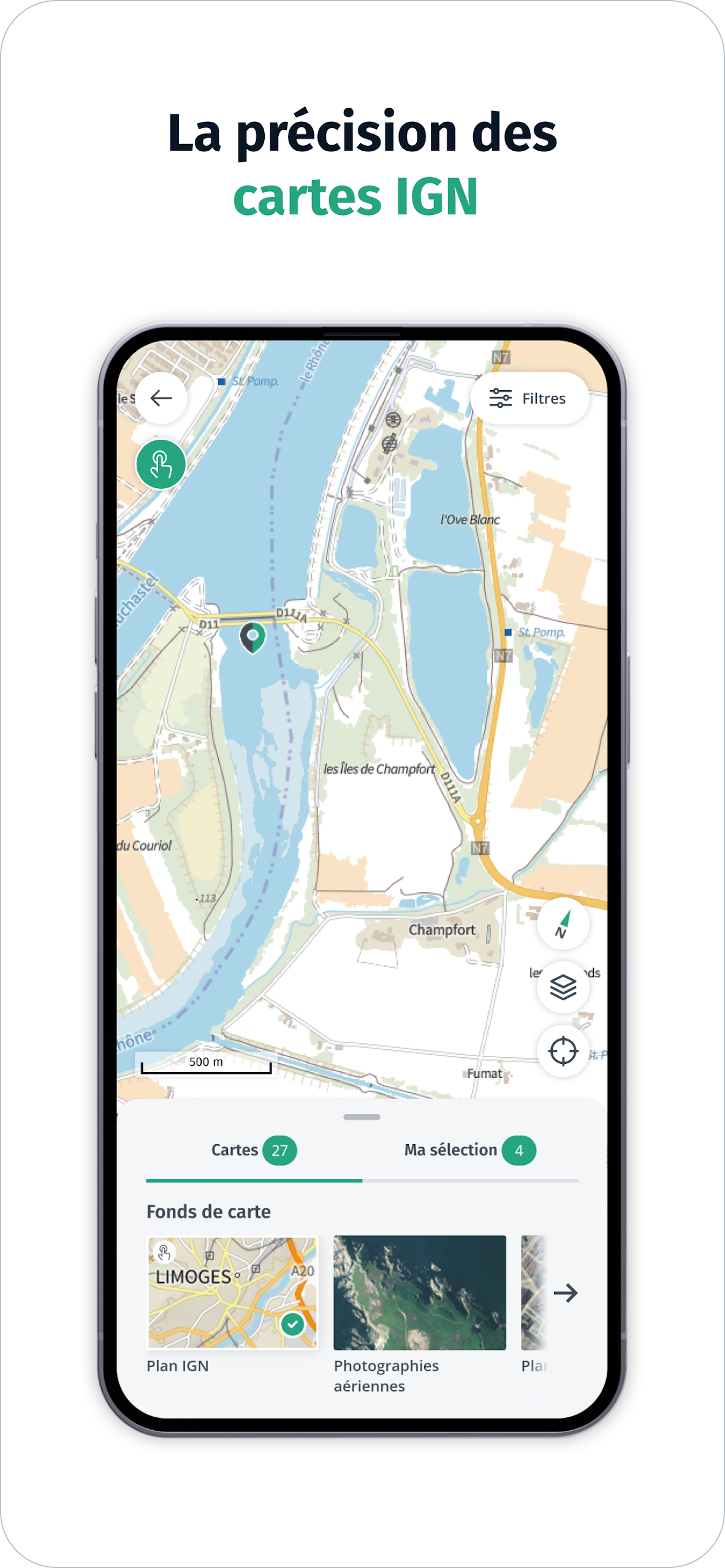
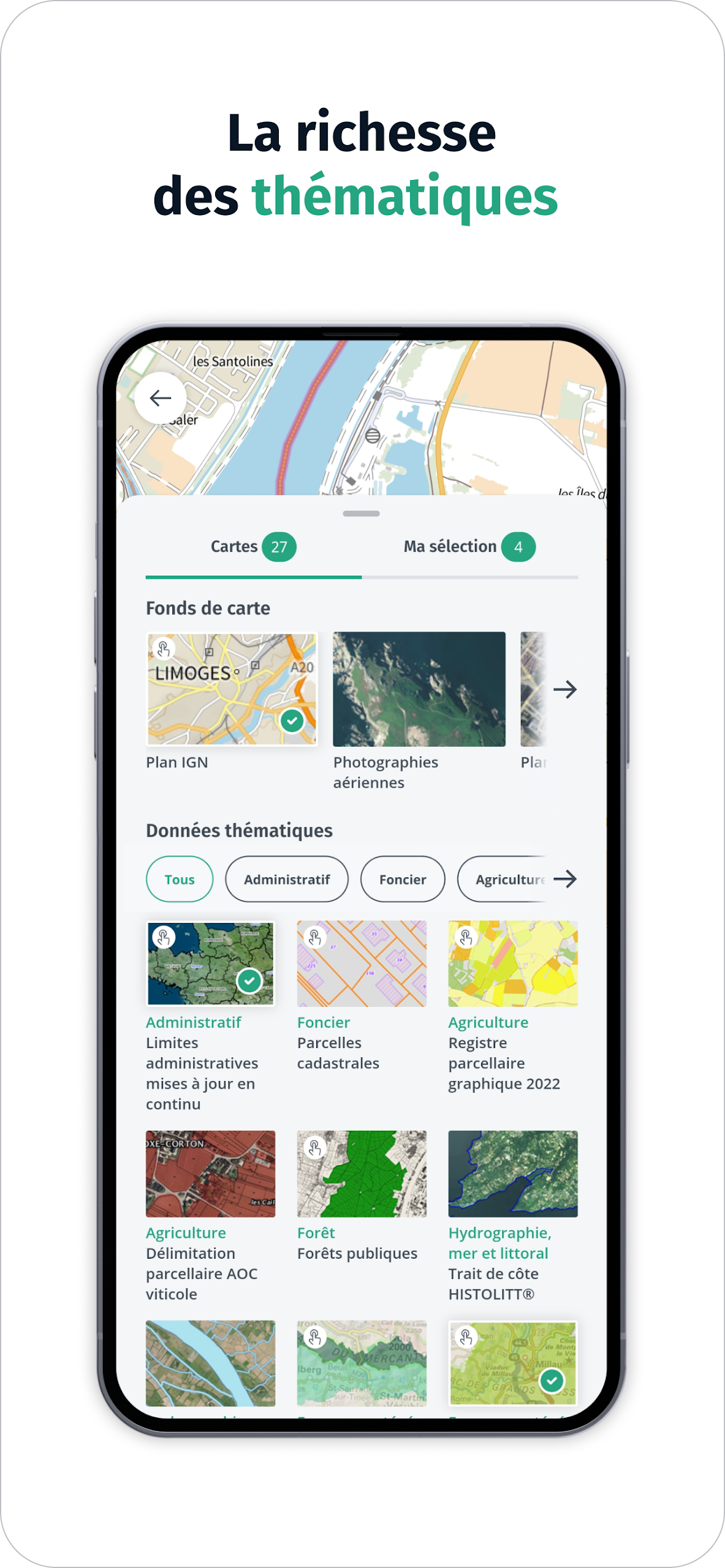
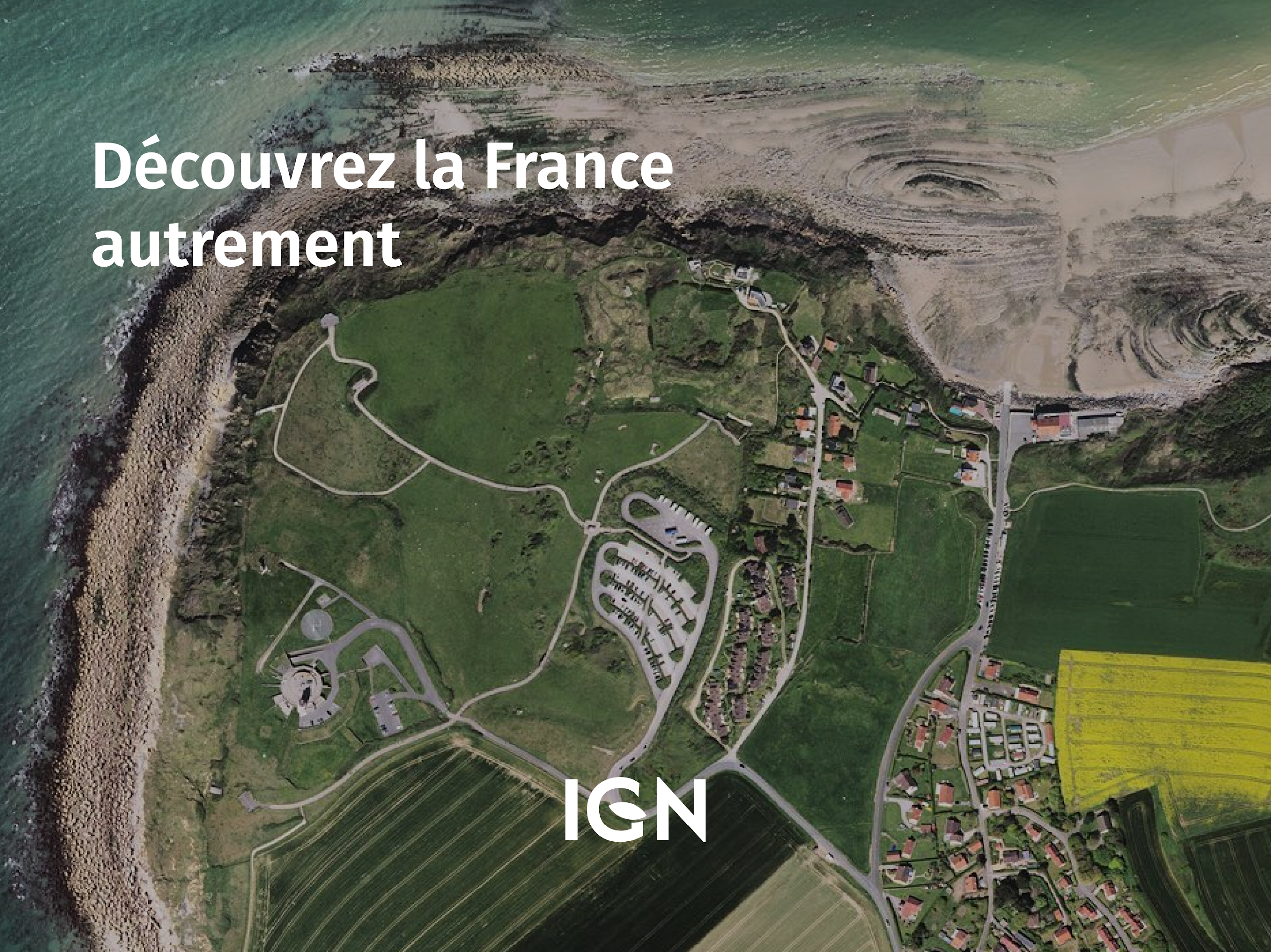
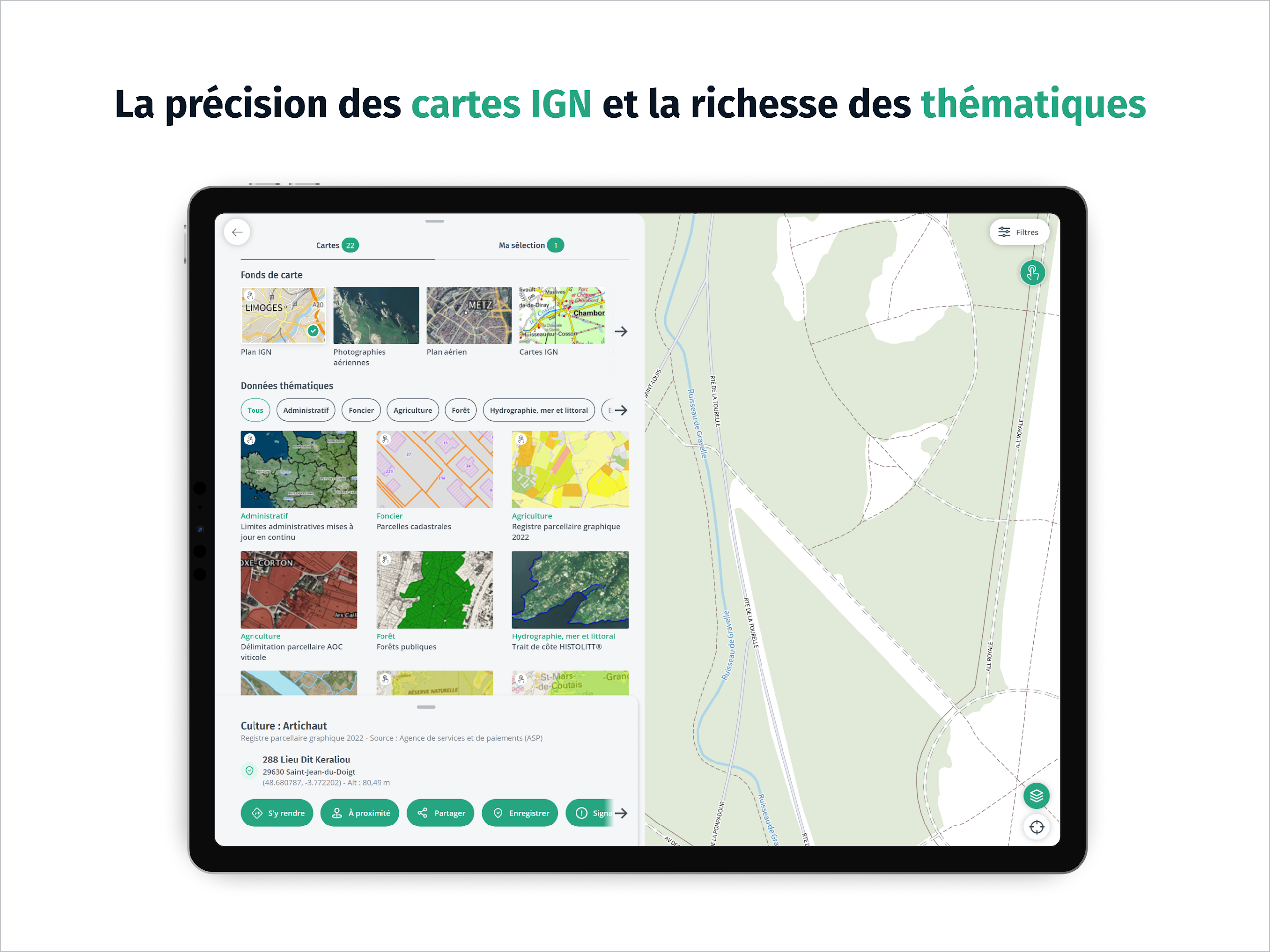
IGN Maps is the 100% free mapping and navigation app designed by IGN, available on mobile and tablet. Experience the precision of IGN maps (IGN plan and topographic maps) combined with the wealth of thematic geographic data provided by IGN and its partners (administrative, land use, agriculture, forestry, tourism, protected areas, transportation...) to explore and understand the French territory.
What We Do
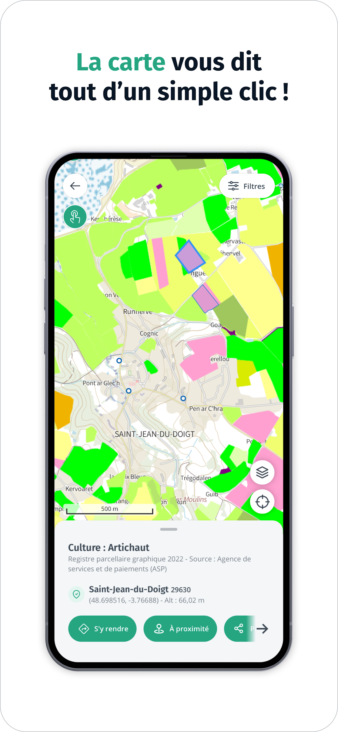
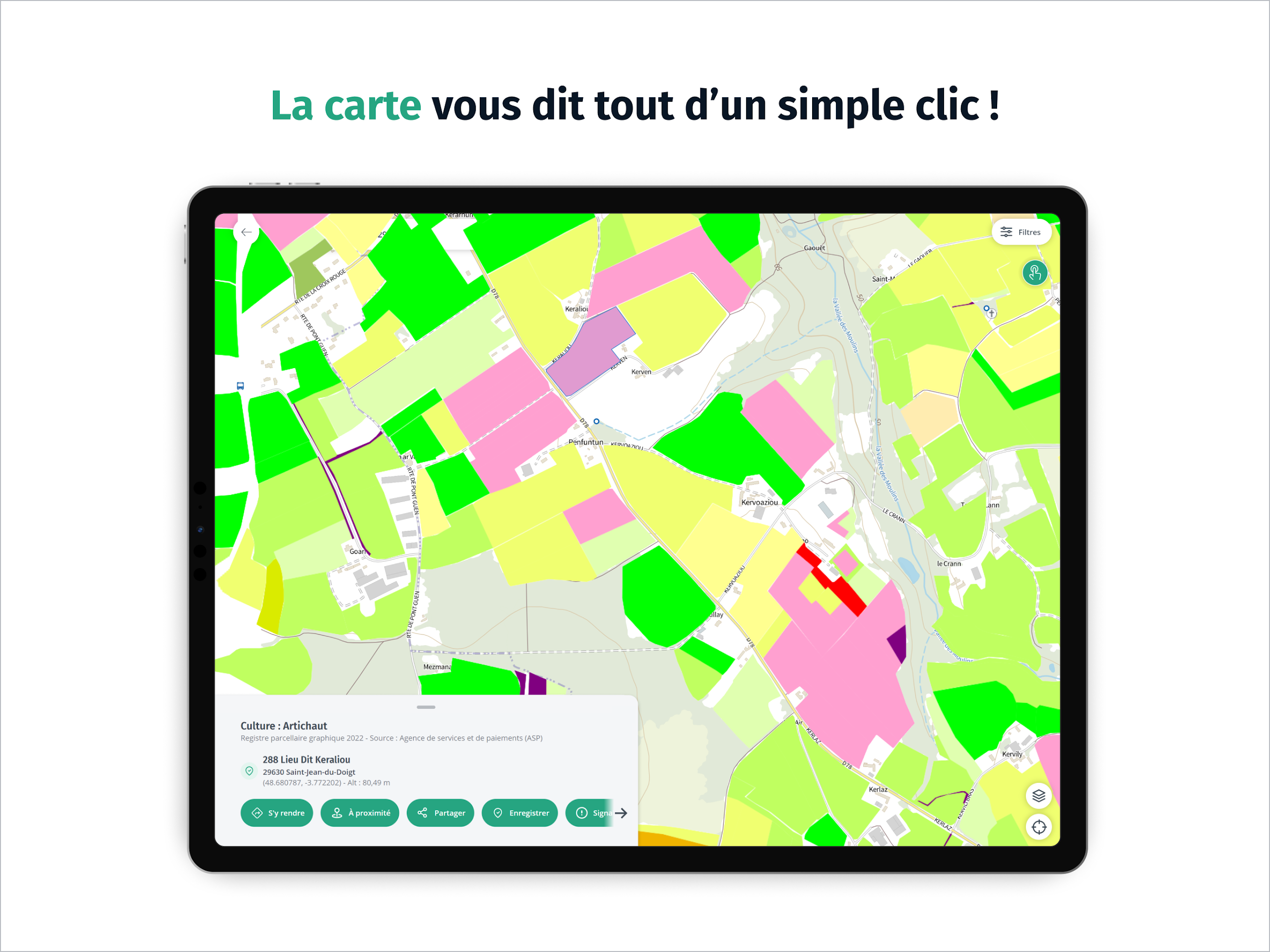
Pro Tip! Click on the interactive map to get additional information about the French territory such as building characteristics or field crop types.
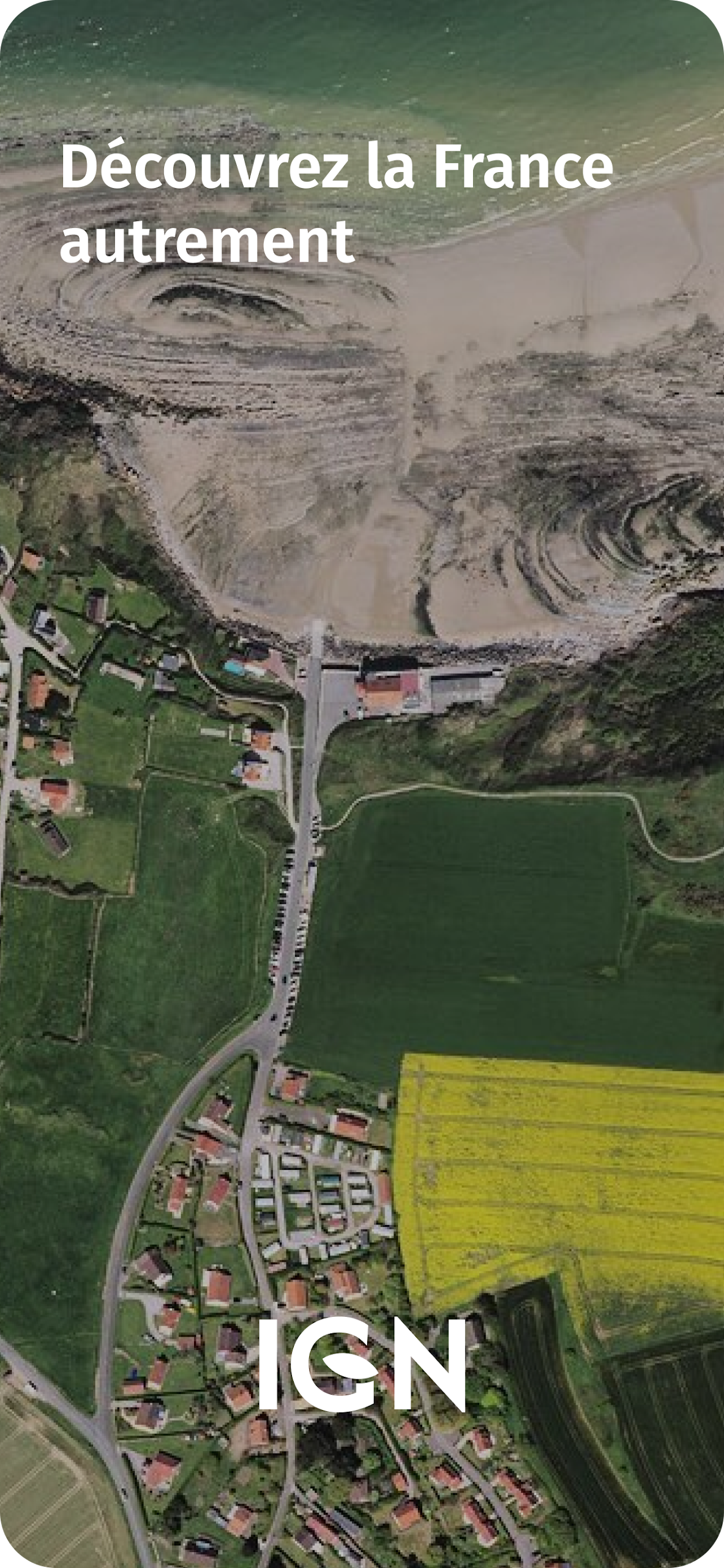
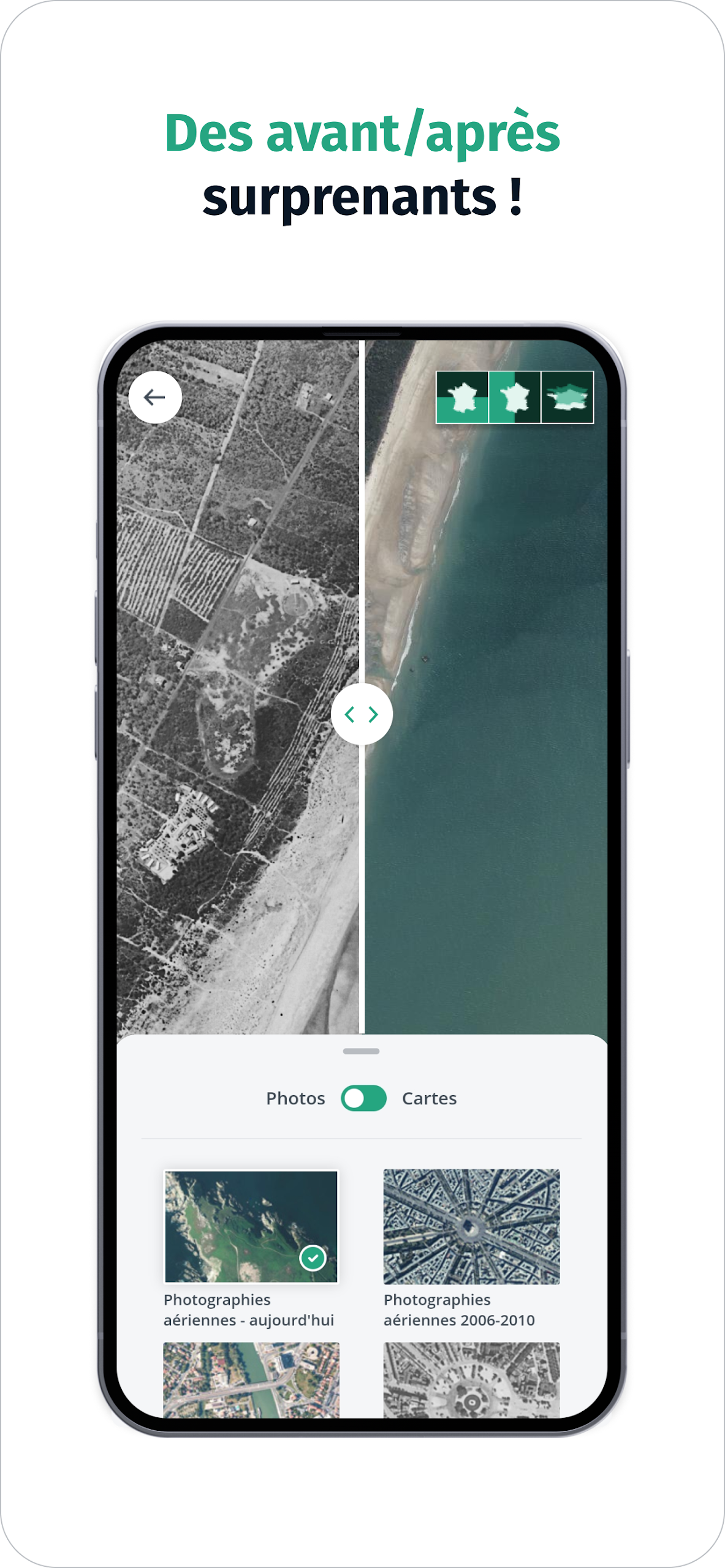
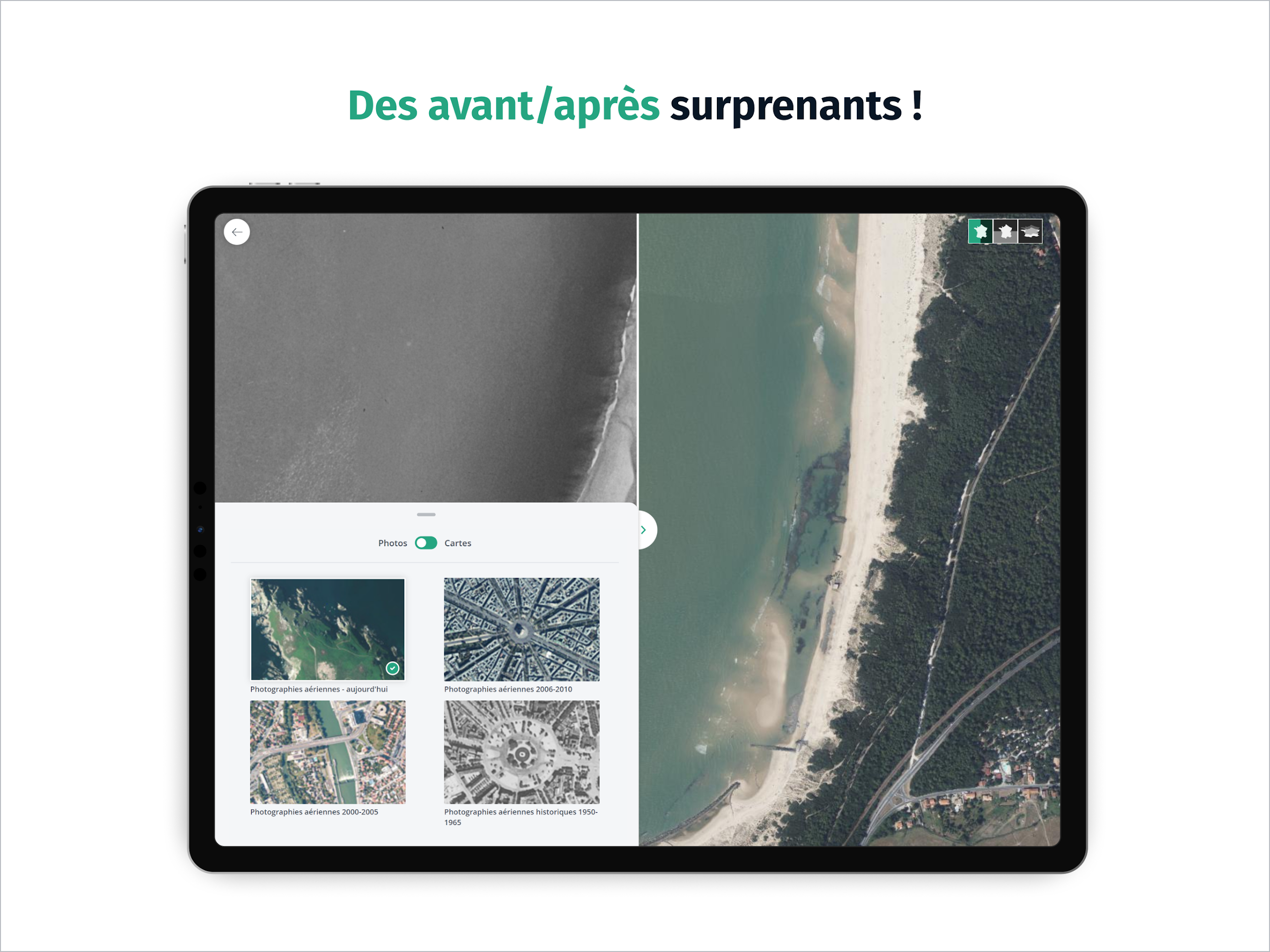
Fly over France and observe the evolution of French landscapes in the era of climate change by comparing, like a geographer, IGN maps or aerial photographs from different epochs. From above, the human footprint on the territory is astonishing!
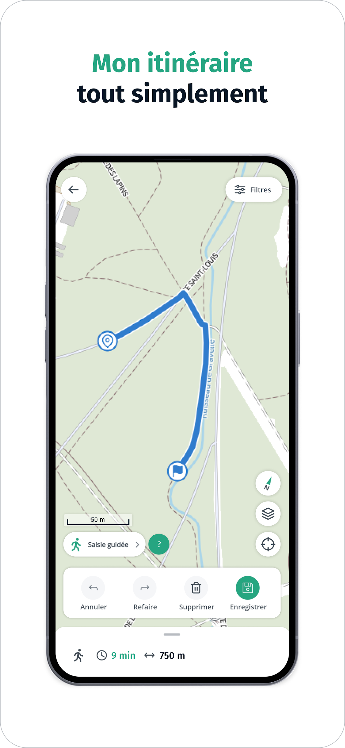
Discover points of interest around you with IGN Maps, an accessible mapping app for everyone that also offers practical tools for moving without being tracked: calculate a route, trace a path, create and save a landmark, display your position and share it with loved ones...
Embark on a journey to explore the French territory with IGN Maps!
Frequently Asked Questions (FAQ)
1 – Display problems
Why can't I see data layers anymore?
Does your phone run on an Android operating system lower than version 10 or do you have an Apple smartwatch?
You may no longer be able to use the Géoportail website and/or application correctly. These difficulties are certainly due to the recent update by the IGN of SSL certificates on several Géoportail services.
An SSL certificate is an electronic identity card that companies add to their website, allowing an encrypted and therefore secure connection (SSL for Secure Sockets Layer). The certificate is an essential element to ensure the integrity and confidentiality of data passing between a user and a website.
Despite the IGN's efforts to resolve the majority of technical problems encountered, some difficulties may persist. You can then implement the corrective actions below in order to enjoy browsing the Géoportail again:
- In the case of the Géoportail application: update the application to the latest Android version of your phone. Warning: the application no longer supports Android versions lower than 7.
- In the case of the Géoportail website, we recommend that you update your Android version if you are browsing with Chrome. If this is not possible, we invite you to browse with Firefox.
Note that in the case of Apple smartwatches, IGN has not yet identified any corrective measures.
What to do if the Geoportal is not displayed correctly?
Following an update, for example, the Géoportail may not display correctly, or may not display the changes made. The reason? The browser you use to consult the Internet stores the files of the websites – and therefore of the Géoportail – to display them more quickly later. You must therefore empty this data, the "cache", to obtain a correct display (on Chrome, Firefox, and Microsoft Edge, press the Ctrl and F5 keys simultaneously).
Which browser should I use to get the best experience with the Géoportail?
To take full advantage of the Géoportail, we recommend that you use a version of the following browsers that is less than one year old:
- Mozilla Firefox
- Google Chrome
- Microsoft Edge
- Safari
As of 08/17/2021, IGN will stop ensuring the compatibility of the Géoportail with Internet Explorer, similar to what Microsoft does for its own applications. IGN will therefore no longer be able to guarantee you an optimal experience of the Géoportail site on this browser.
Why is the data selected via the “Maps” menu not displayed?
Some data is only displayed on a specific scale range and in a restricted area: check that the selected data is likely to be displayed at your visualization scale and in your territory via the information available in the information sheet (click on the "information" icon).
What to do if the map is blank/empty or some tools do not appear?
You will find the aerial photograph proposed by default when you first consult the Géoportail by clicking on this link .
If the problem persists:
- Clear your browser cache (on Chrome, Firefox, Microsoft Edge and Internet Explorer, press Ctrl and F5 simultaneously).
- Check that your browser version is the most up-to-date.
- try to connect to the Géoportail site from another internet browser.
2 – Consulting the maps
How to access the Geoportail map backgrounds and data?
 To access the Geoportail map backgrounds and data, click on the “Maps” main menu access button at the top left of the screen.
How to switch to full screen?
 Click the "Switch to full screen" icon at the bottom right of the viewing interface. To switch back to normal mode, click this icon again.
How to display map legends?
 To view the map legend, click the legend button located on the right in the map interface.
How to adjust the opacity of a map?
To adjust the opacity of a map:
1. Open the Card Manager;
2. Click on the settings management icon (gear);
3. Adjust the opacity.
How to delete data from the card?
To delete data from the map:
1. Open the Card Manager;
2. Click on the settings management icon (gear);
3. Click on the trash can icon.
How to display IGN maps and aerial photographs simultaneously?
To display IGN maps and aerial photographs simultaneously:
1. Open the Card Manager;
2. Activate the “Aerial Photographs” background map via the “Maps” main menu at the top left;
3. Drag the “Aerial Photography” data to the top of the data stack;
4. Click on the settings management icon (gear) and adjust the opacity to 50%;
5. Activate the “IGN Maps” background map via the “Maps” main menu at the top left.
You can also click on this link to directly display the aerial photographs and IGN maps at 50%.
How to position data in the foreground / background?
To change the data ordering:
1. Open the Card Manager;
2. Drag the data to the desired level in the stack.
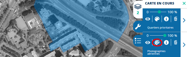
How to display black and white basemaps?
Displaying Geoportail base maps in black and white improves the readability of the superimposed data.
To display black and white basemaps:
1. Open the card manager
2. Click on the settings management icon (gear)
3. Click on the “color/NB” icon (paint palette)
3 – Maps, photos, cadastral parcels and other data…
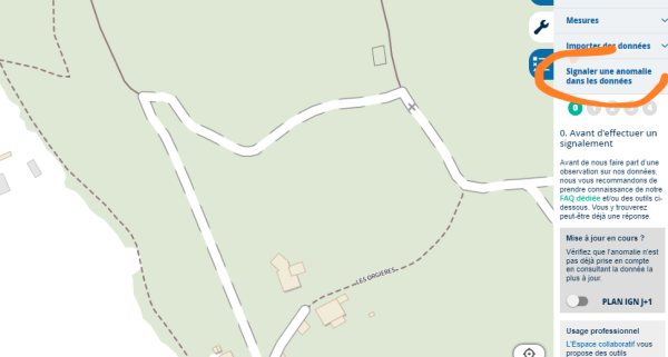
I noticed an anomaly in the data
The IGN maps and data published on the Géoportail are updated regularly. However, you may notice discrepancies between the terrain and its representation by the IGN. These are, for example, linked to recent developments.
You can help improve the accuracy of the Géoportail information via the Report a data anomaly tool available in the menu to the right of each displayed map.
In four quick steps, you can report to us, for example, a change in the layout of a road, a change in the name of a street, the construction or disappearance of a building, etc.
We draw your attention to the fact that certain themes cannot be the subject of valuation:
- Discrepancy between cadastral parcels and aerial photography: (see FAQ: A discrepancy appears when superimposing cadastral parcels and aerial photographs, why?)
- Anomaly on the cadastral parcel layer: The IGN only plays a role in disseminating the cadastral plan. If you notice an anomaly on the latter, we invite you to contact the DGFIP cadastral service
- Private road: The primary purpose of the IGN is to map France in detail by representing all the elements on the ground of the national territory, whether they are public or private. To do this, it publishes a topographic map at 1:25,000 called "base". According to the specifications applied to this document, all roads (road, path, lay, track or trail) visible on aerial photographs or existing on the ground are represented on our maps. The representation of a road in no way takes precedence over its legal status (public, private, easement, free access, regulated or prohibited, etc.), its cadastral reality and its use.
- Address: The naming of roads and addressing are part of the powers of the municipalities:
- If you are an individual, you must contact your town hall,
- If you are a municipality, referencing is done on the following site: https://adresse.data.gouv.fr .
- Building: the buildings shown on our maps correspond to those visible on the last aerial photography mission. For any construction or modification after this aerial photography (PVA), we invite you to wait until the next update. Find the PVA dates in this table.
How to display IGN maps at 1:25,000 (topographic maps)?
To display IGN maps at 1:25,000, open the main “Maps” menu at the top left, click on “All base maps” and activate the “IGN topographic map” base map.
You can also click on this link to directly display the IGN maps at 1:25,000.
How to display aerial photographs?
To view aerial photographs, open the main menu “Maps” at the top left and activate the “Aerial Photographs” basemap.
You can also click on this link to view the aerial photographs directly.
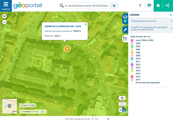
How do I find out the dates of aerial photography?
The dates of the shootings by department can be known:
- by consulting this regularly updated document
- You can also consult this map which will tell you the date of the shot with a simple click
How to display cadastral parcels?
To view cadastral parcels, open the main menu “Maps” at the top left, click on “See all base maps” and activate the base map “Cadastral parcels”.
You can also click on this link to directly display the cadastral parcels.
The cadastral parcels of my municipality have disappeared. Why and how can I find them?
The “Cadastral parcels” data comes from the computerized cadastral plan (PCI) vector of the DGFiP.
Some municipalities may not yet be covered by the PCI vector.
For these municipalities, you can consult the Cadastral parcels data (2013-2018) .
A discrepancy appears when superimposing Cadastral Plots and Aerial Photographs. Why?
The map of cadastral parcels is now based on the IGN Parcellaire Express data, the primary source of which is the Computerized Cadastral Plan (PCI) vector of the DGFiP.
It has not been subject to geometric corrections: a shift in relation to other data from the Géoportail (aerial photographs in particular) may therefore appear.
It was previously based on the IGN BD Parcellaire data; this benefited from geometric corrections but is no longer updated.
The Parcellaire Express data is now updated every quarter (compared to every three years for the BD Parcellaire data).
Old editions of cadastral parcels based on the BD Parcellaire and benefiting from geometric corrections remain available:
- Cadastral parcels (2013-2018)
- Cadastral parcels (2008-2013)
How to display administrative boundaries?
To display administrative boundaries, open the main menu “Maps” at the top left, click on “Territories and transport” then “Territory description” and activate the “Administrative boundaries” data.
You can also click on this link to directly display the administrative boundaries.
How to accentuate the relief of your cards?
The “Fade” data allows you to accentuate the relief of your maps.
To display the fading, you can either search for the data via the search engine by typing “Fade”; or open the main “Maps” menu at the top left, click on “Territories and transport” then “Territory description” and activate the “Fade” data.
You can also click on this link to directly display the IGN maps and the “Fallout” data.
Where are the downloadable heritage data (aerial photographs, Cassini maps and General Staff maps)?
Downloadable heritage data (aerial photographs, Cassini maps and general staff maps) are available on the website monterletemps.ign.fr .
4 – Printing and tools
How to print a map / generate a PDF file?
Click on the print icon, give your card a title, optionally enter a comment and click on the Print button.
Then choose a virtual PDF printer.
If you do not have a PDF printer installed on your computer, you can:
- use Google Chrome browser
- install a free PDF printer (e.g. doPDF on PC)
What to do if you have difficulty printing?
If you have difficulty printing from the Géoportail site:
- Clear your browser cache (on Chrome, Firefox, Microsoft Edge and Internet Explorer, press Ctrl and F5 simultaneously)
- Check that your browser version is the most up-to-date
- try to connect to the Géoportail site from another internet browser
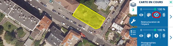
How to edit your saved sketches?
To edit a sketch:
1. Log in to your personal space
2. Load your previously saved map or sketch
3. Click the “More Tools” icon (gear) corresponding to your sketch layer
4. Click on the “Edit Layer” icon (pencil in a circle)
5. Edit your sketch
6. If you wish, change the name of your sketch
7. Click the “Save” button in the right panel
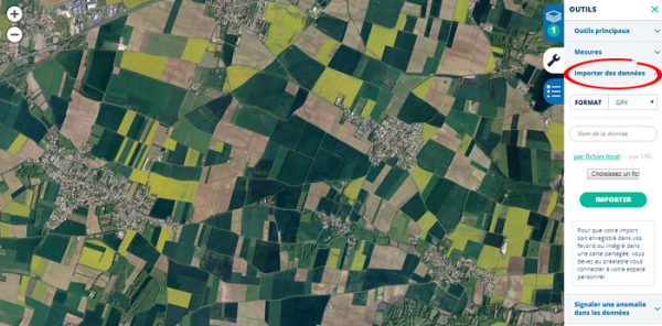
How to import data?
You can enrich your personalized maps by importing your own data or by importing data distributed by a service other than the Géoportail.
To import data:
1. open the tools menu to the right of the map area and click on Import data
2. select the format of the data you want to import (KML, GPX, GeoJSON, WMS, WMTS or vector tiles)
3. give a name to this data
4. select the data to import onto your computer or enter the address (url) of the data if it is distributed by a server
5. click on “import”
If you are logged in, you will find the imports you have made in your personal space.
5 – My account
How do I access my account?
Click on the star at the top right. Enter your username (email address) and password.
If you have difficulty logging in, click on “Forgotten password”.
What to do if I see the message “An error has occurred”?
If you see the message "An error has occurred" when you try to log in to your account, contact us .
Our teams will intervene quickly so that you can connect to your account again.
How do I access my favorite places?
 Your favorite places are now collected with saved maps. To access them, click on the star icon at the top right of your screen.
How do I access my saved cards?
To access saved maps, click the star icon at the top right of your screen.
6 – Calculations of routes and isochrones
What data is used by the route calculation?
The route calculation and isochrone/isodistance services use the IGN geographic databases ( BDTOPO and BDCARTO ).
How reliable can I be in the route calculation?
This tool is offered in beta version. The information obtained is therefore to be used for information purposes only. In addition, the route calculation does not take into account the state of road traffic, ongoing works, etc.
What should I do if I find an error in the route calculation?
You can report this error to us via the contact form.
What is an isochrone/isodistance calculation?
An isochrone calculation allows you to display on a map all the areas that can be reached, on foot or by vehicle, from a specific point within a specific time frame. An isodistance calculation allows you to display on a map all the areas that can be reached, on foot or by vehicle, from a specific point up to a specific distance.
For more information: IGN geoservices
7 – Reuse of data
Can I reuse data from the Géoportail?
In the event that only IGN content is included in the screenshot or printout, and unless otherwise stated in the information for each data layer, IGN authorizes the following reuses:
- documentary use (for the purpose of illustrating a document, to make information available for consultation where the IGN data does not constitute an essential element of the document. This type of use is inherently non-profit and does not seek to enhance or promote the corporate purpose of those who implement it); the images do not include any georeferencing coordinates;
- printing for use not providing direct or indirect economic advantage, within the limit of A4 format and a resolution of 150 dpi (i.e. approximately 1230*1750 pixels);
- insertion in a site, blog, sharing platform or other web application allowing consultation without registration to all Internet users, within the limit of one or more images of maximum size 1000×1000 pixels or equivalent, or approximately 1,000,000 pixels; any publication must be accompanied by the Géoportail logo and the IGN logo or the literal mentions "© IGN" and the year. However, these mentions must only indicate the origin of the screenshot without causing confusion between the publication site and the Géoportail.
Any other use of IGN data is subject to a license available from the IGN correspondent network.
In the event that third-party content is included in the screenshot or printout, and unless otherwise indicated in the information for each data layer, screenshots and printouts of third-party content from the geoportail.gouv.fr site are authorized under the same conditions as for IGN data.
For all other cases (reproduction of a larger extract or use for commercial purposes), we invite you to contact us.
How do I insert a dynamic map into my own site?
Select a base map, and possibly the data of your choice. Click on the "Share" icon, at the top right of the screen. Copy the proposed HTML code, and paste it into your content management tool (in HTML mode) or your page creation tool. The base map most suitable for viewing on screen is Plan IGN.
The “Annotate Map” tool lets you add your own information (for example, a location icon, text, or a polygon). To create your own custom map, be sure to log in (or create an account) and save your sketch so that it is integrated into the map you want to share.
8 – Navigate in 3D
How do I navigate in 3D directly in my browser?
You can navigate in 3D on the Géoportail (access via the "3D" button at the bottom right of the screen), directly in your Internet browser, without downloading a plugin or installing additional software, provided you use an up-to-date version of one of the following browsers:
- Google Chrome
- Firefox
- Microsoft Edge
- Safari
3D navigation in the Internet browser is currently restricted to viewing on a computer; it is not suitable for mobile devices.
View orientation
Hold down the Ctrl key while moving around the map to change the view orientation.
Known limitations
- Data
- Warning: the entire Geoportail can be viewed in 3D, but some data is not suitable for this type of visualization. This is the case for data designed for 2D display. With this data, points of interest (schools, hospitals, train stations, etc.) fall into this category, for example: the pictograms associated with them will appear stuck to the ground.
- Some data presenting a difference in representation depending on the display scale (example: “IGN map”) may present connection problems when viewed in 3D.
- Tools
The measurement tools, “Annotate the map”, “Calculate a route”, “Report an anomaly” are not currently available in 3D.
Switching to 3D mode does not allow you to save the elements created with the tools. If you have customized a map before activating 3D mode, you must log in to your personal space and save your work.
What to do if you have difficulty viewing 3D?
To view maps in 3D, click on the 3D icon at the bottom right of the map interface.
If 3D does not appear:
- Clear your browser cache (on Chrome, Firefox, Microsoft Edge and Internet Explorer, press Ctrl and F5 simultaneously)
- Check that your browser version is the most up-to-date
- try to connect to the Géoportail site from another internet browser
Why is Internet Explorer not a supported browser?
The technology used to enable 3D navigation in the browser (WebGL) is only partially supported starting with Internet Explorer version 11. Even with this version (IE 11), the performance is not satisfactory enough and does not guarantee a good user experience.
Can I navigate in 3D on a tablet?
The 2D/3D toggle button only appears if the viewport size is large enough. It may appear on some tablets. However, 3D navigation requires strong graphics capabilities from the device used, typically achieved by desktop computers but rarely by mobile devices.
3D navigation on a mobile terminal is therefore not recommended if you want to have a pleasant browsing experience.
Why am I not getting the 3D switch button?
The 2D/3D toggle button only appears if the viewport size is large enough (620 pixels minimum width).
How to display an annotated map (a sketch) in 3D?
It is not possible to directly annotate a map in 3D mode. However, it is quite possible to view sketches made in 2D mode in 3D.
The same applies to all data in your personal space.
What data is used to display 3D relief?
The relief is generated from RGE Alti data for the French territory. It is supplemented by global altitude data provided by NASA (SRTM 3) for other areas.
Can I share a link to a 3D map?
The link received by the user will open a 3D visualization, according to the current point of view when sharing. The camera orientation is not transmitted for now, but this is part of the upcoming improvements to the 3D visualization.
Can I insert a 3D iframe into my site?
The iframes generated from the share function only provide a 2D view.
Why a beta version?
The 3D visualization offered in the browser is still experimental. It will evolve soon via functional improvements.
9 – Geographic coordinates
What projection is used by the Géoportail?
The Mercator system used on the Geoportal is Mercator EPSG 3857. Mercator EPSG 3857 is a spherical Mercator projection coordinate system.
What is what3words?
what3words is an experimental addressing system based on the association of three words.
For example, here is the address of the IGN in what3words format: intégrale.entonner.invitant
The what3words location system is not official. However, it allows you to locate (with an accuracy of 3m) any point on the globe very simply.
Locate yourself at a what3words address
You can locate a place whose what3words address you know by typing the three words into the search engine.
Know the what3words address of a place
You can know the what3words address of a place by right-clicking on the map and choosing the option "Address/coordinates of the place".
More information about what3words
10 – Other questions
What should I do if the search engine result does not meet my expectations?
The Géoportail search engine allows you to search numerous data sources, such as addresses, places, road landmarks, contents of the Géoportail or the Géocatalogue .
To do this, simply type the desired word in the search bar (next to the magnifying glass).
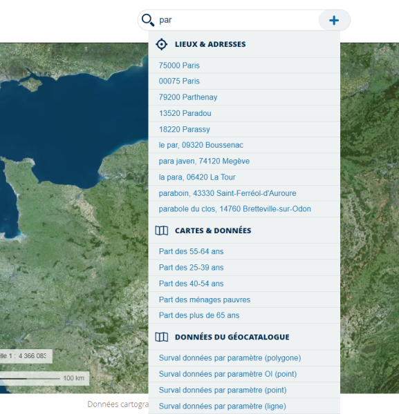
By default, the number of results returned by the engine following a search is limited to 5 among places, 5 among addresses and 5 among data. These may not match your expectations.
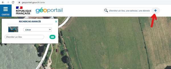
In this case, it is possible to activate the so-called "advanced" search by clicking on the " + " button located on the right in the search bar. The latter allows you to target the results according to their origin: places, road landmarks, addresses, cadastral parcels, coordinates, maps and data or even data from the Géocatalogue. The search is therefore more precise because it is limited to the chosen category only.
In practice, to get more search results:
1. Click on the “+” button to the right of the input box
2. Select the data category from the drop-down menu that appears on the left of the screen
3. Enter the word that constitutes your search
4. Click “OK”
5. You can thus obtain up to 25 results
Can I blur my house or property?
The aerial photographs taken by the IGN as part of its general interest mission are, on the one hand, considered as public data by law n° 78-753 of July 17, 1978, as amended, relating to freedom of access to administrative documents and the reuse of public information.
Furthermore, these photographs do not contain any personal data within the meaning of Law No. 78-17 of 6 January 1978, as amended, relating to information technology, files and freedoms. Consequently, we cannot blur the surface of your property shown on the aerial photographs.
Where to buy an IGN map or an aerial photo?
To purchase an IGN map or an aerial photo, visit the IGNrando' website or the IGN professional space .
Who funds the Geoportal?
The IGN (National Institute of Geographic and Forest Information) finances the Géoportail as part of its public service missions.
Who administers the Geoportal?
The Géoportail as a visualization tool is administered by the IGN (National Institute of Geographic and Forest Information). The cataloguing tool with which it is interfaced (the Géocatalogue) is administered by the BRGM (Bureau of Geological and Mining Research).
What is INSPIRE?
The INSPIRE Directive, developed by the European Commission's Directorate-General for the Environment, aims to establish a spatial data infrastructure in Europe to ensure interoperability between databases and to facilitate the dissemination, availability, use and reuse of geographic information in Europe.
In France, as part of the transposition of the directive, the ordinance specifies the definition and the modalities of the network of services that the public authorities implement to meet the requirements of INSPIRE. The Géoportail and the Géocatalogue were designed to become constituent elements of it.
For more information on the INSPIRE directive, visit the website of the National Council for Geographic Information (CNIG) .
- Version3.3.32
- UpdateJul 31, 2025
- DeveloperIGN-France
- CategoryTravel & Local
- Requires AndroidAndroid 6+
- Downloads942K+
- Package Namefr.ign.geoportail
- Signature1eac1a658d18201224d929dd422cdf08
- Available on
- ReportFlag as inappropriate
-
NameSizeDownload
-
13.01 MB
-
12.63 MB
-
12.57 MB


cadastrale are useful
helpful and in-time guidance
too faint layer of sattelite
not working with Google