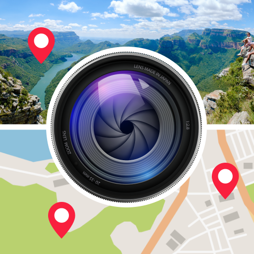
GPS Photo: With Location & Map - Tag photos with location
Capture and store photos tied to exact GPS coordinates for easy navigation.
- 2.1.0 Version
- 1.3 Score
- 5M+ Downloads
- In-app purchases License
- 3+ Content Rating


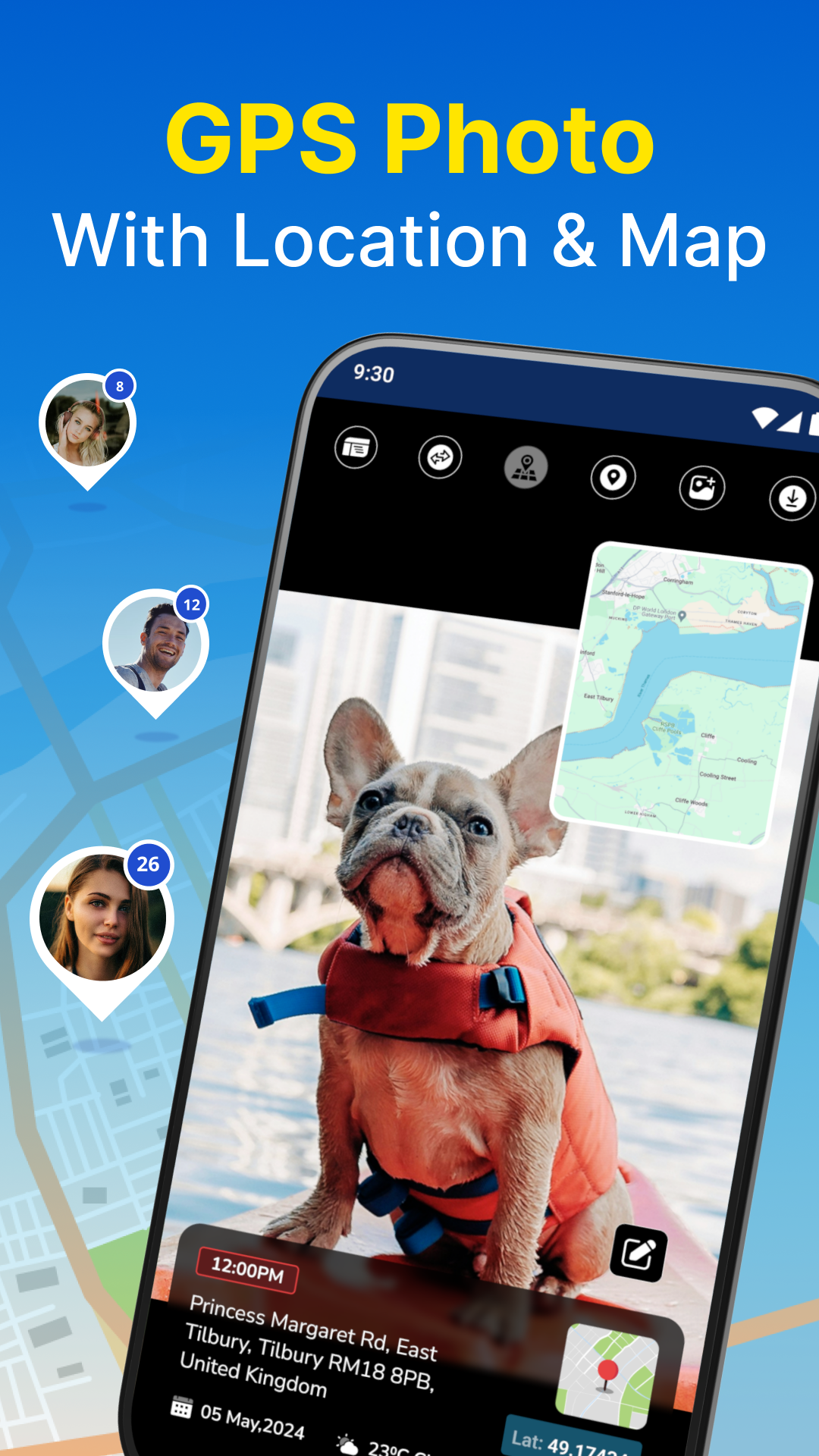


📸 With the GPS Photo app, users can enrich their photos with detailed information like location, latitude and longitude coordinates, map view, and weather conditions. The app automatically adds location details to photos captured using its camera and can retrieve location information for images already saved in the mobile gallery. It is a must-have tool for travelers and photography enthusiasts.
Feature Highlights:
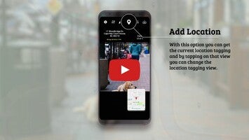
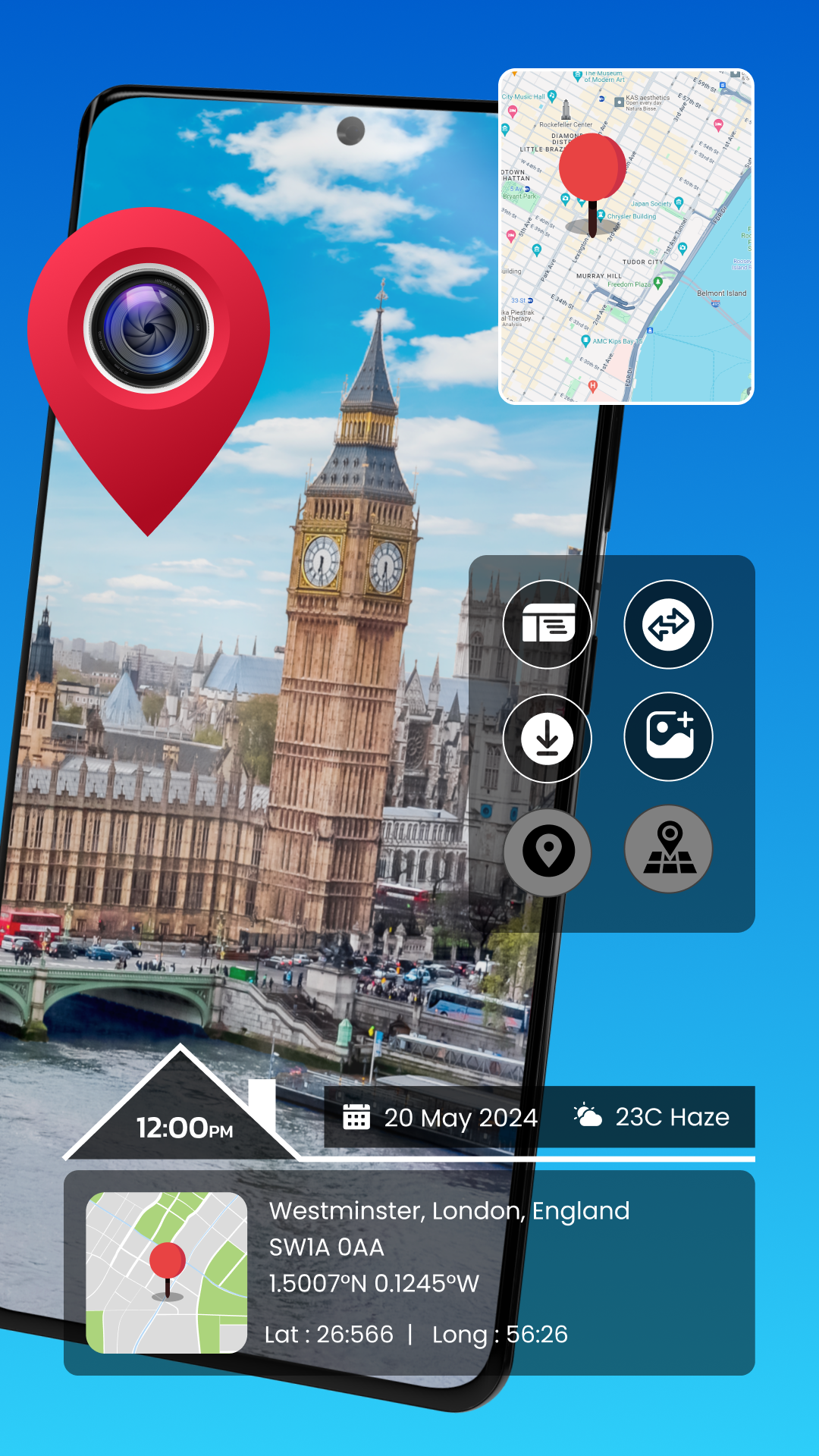
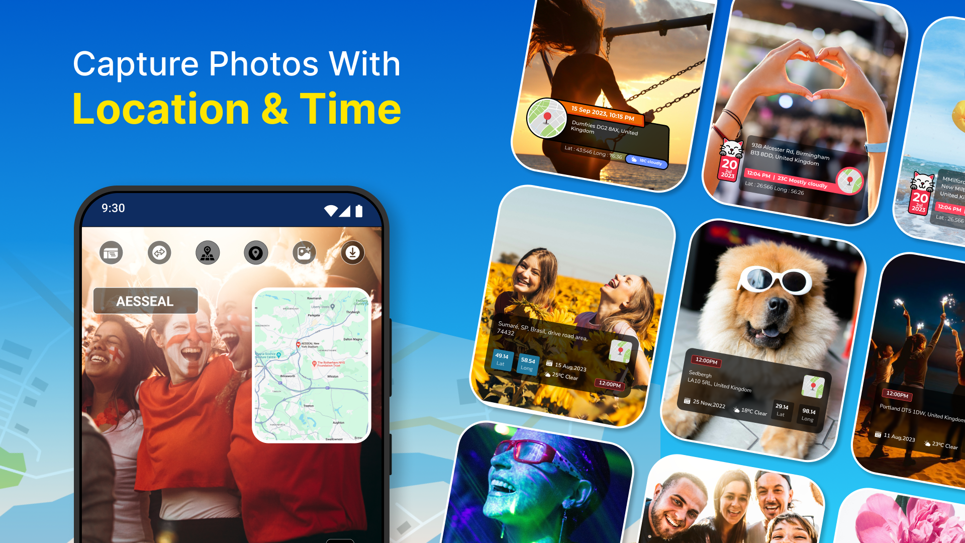
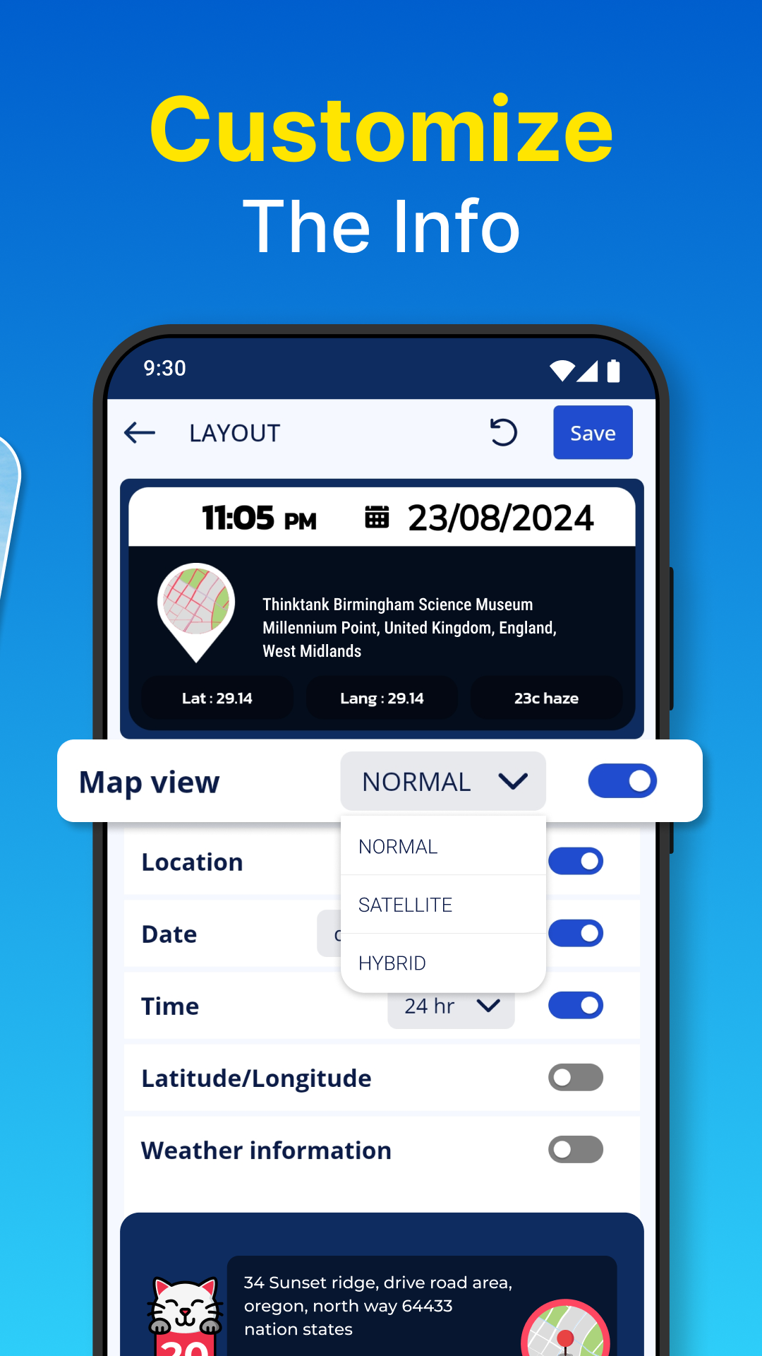
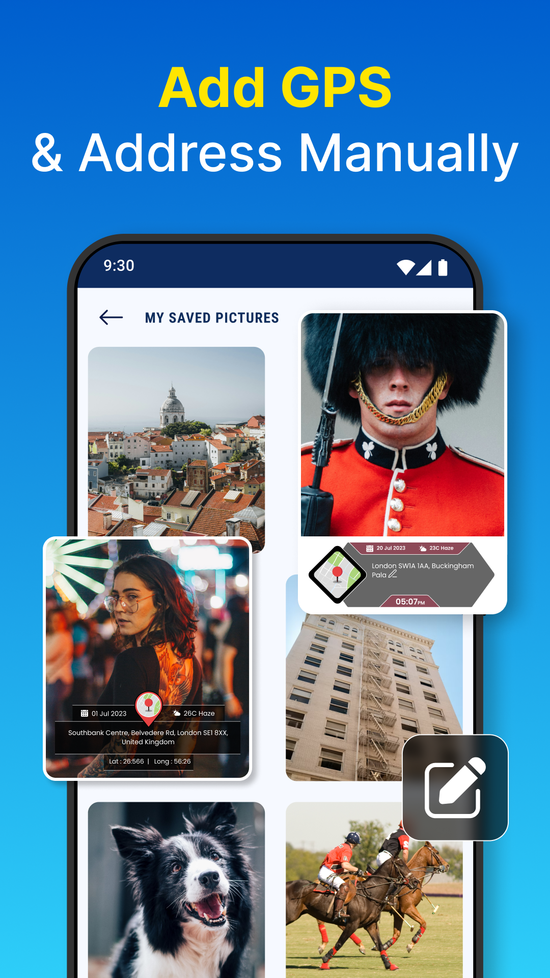
📷 Enhanced Camera: Capture or import photos with added details such as current location address, coordinates, map view, and weather data, allowing customization of location layouts.
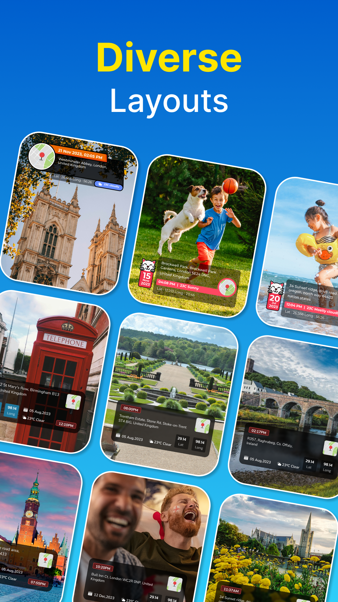
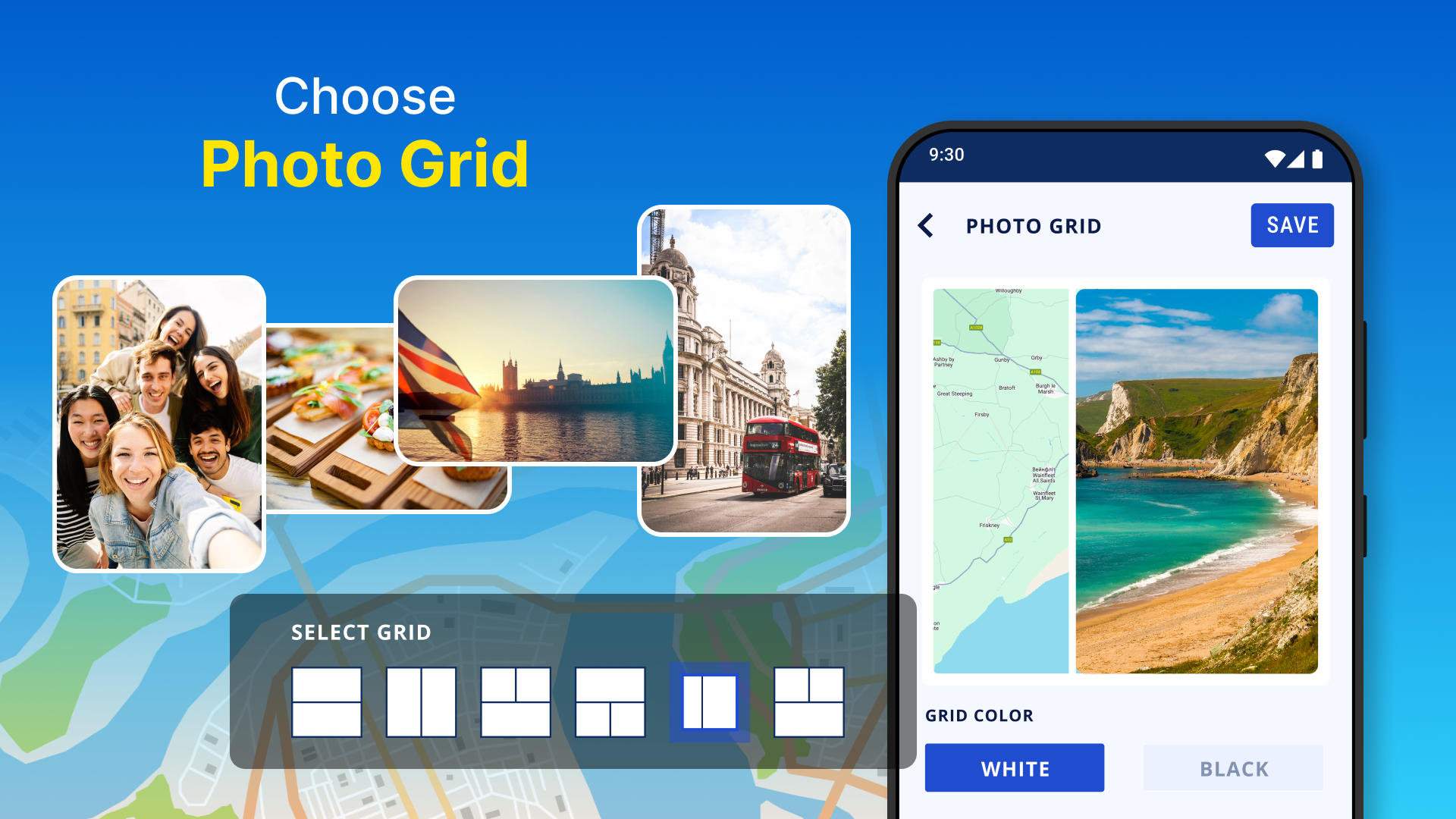
🖼️ Photo Grid: Craft collages featuring location views using various grid designs, trace routes on maps, and include travel icons for a unique touch, selecting from a range of attractive options.
📸 Camera Function: Snap photos in the app to receive instant location addresses and weather information, complete with a map view.
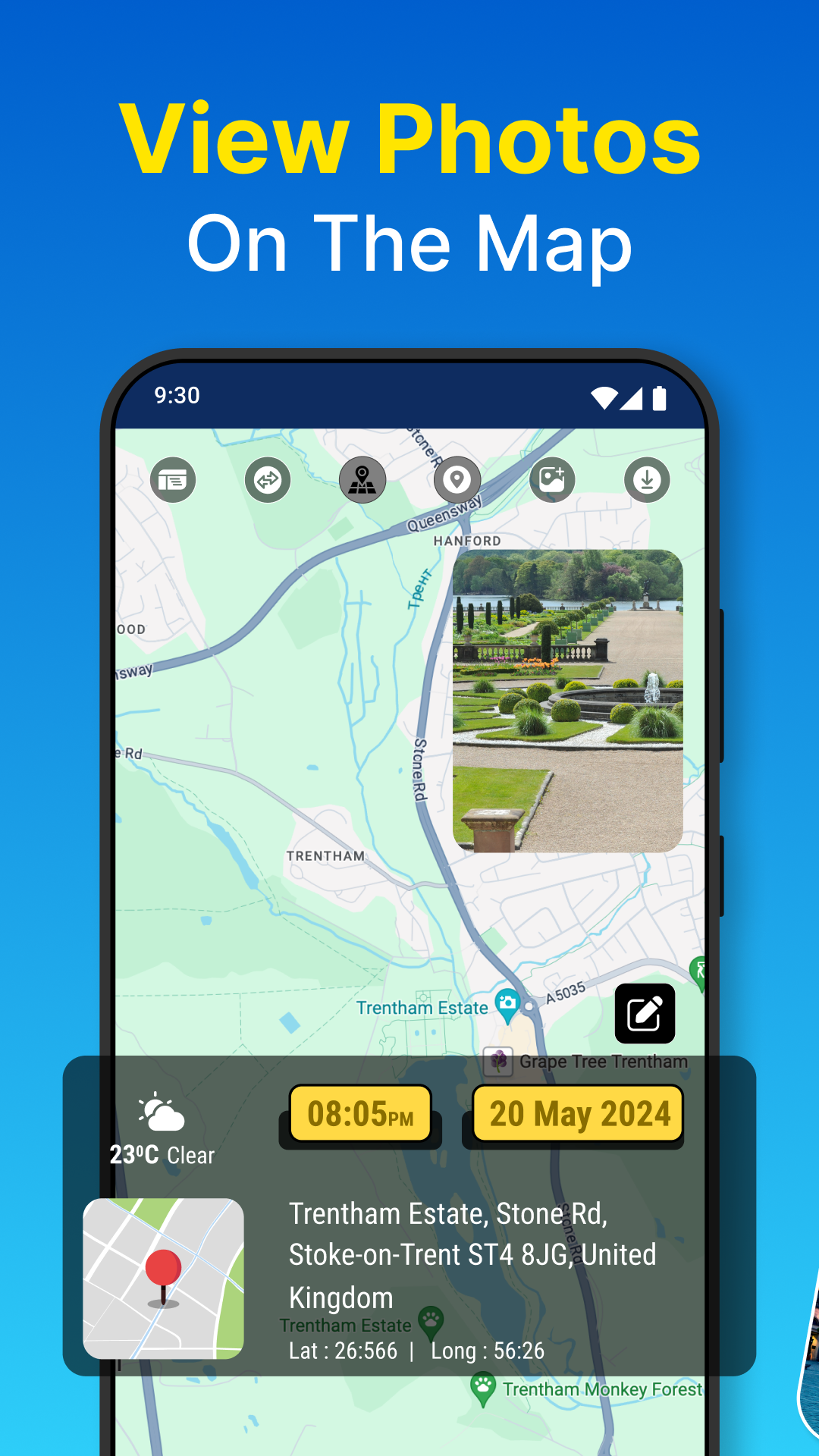
🌆 Gallery Access: Choose images from your gallery, with stored location data displayed in detail; manually input location information to have each photo paired with a map view.
📅 Album Organization: Sort your images into albums by year and month, each showcasing specific location details, enabling you to reminisce with trip-specific information.
🗺️ Map View: See all your photos on a map and navigate them by their locations.
Quick App Highlights & Usage Scenarios:
📷 Effortlessly capture images with accurate location and weather details.
🌍 Organize your memories by exploring photos on an interactive map.
🖼️ Design stunning collages featuring customizable travel-themed elements.
📸 Receive immediate access to real-time location and weather info for your pictures.
📅 Arrange your gallery neatly with date-centric albums and location tags.
🗺️ Append location data to existing photos in your mobile gallery.
🌆 Elevate your images with appealing custom layouts and icons.
📸 Automatically fetch location details for in-app captures.
💾 Conveniently manage and store your taken images.
🌆 Ideal for both ardent travelers and photography enthusiasts alike.
Embrace and make the most of the app’s features.
Permission Details:
1] 📷 Camera: Allowance needed to capture images.
2] 💾 Storage: Permission necessary to access the gallery and save captured images.
3] 🌍 Location: Access required to obtain coordinates for displaying current location on the map, showcasing gallery images on the map, and overall functionality.
Using Guide
GPS Photo: With Location & Map is an innovative application designed to infuse your photography with a layer of geographical intelligence. Whether you're a vivid traveler or a photography aficionado, you’ll discover the convenience of attaching precise location coordinates to each photo snapped or uploaded from your gallery. This tool enriches your memories with context, providing latitude, longitude, and a map location, as well as weather conditions at the moment the photo was taken.
With the Advanced Camera feature, you effortlessly capture or upload images accompanied by significant data, including current location address and meteorological insights. It enables you to personalize your pictures with customizable location layouts, elevating the storytelling of your travels.
Its Photo Grid function allows you to create captivating collages complete with map views, travel routes, and various grid designs. The selection of travel icons offered adds a charming touch to your visual narratives.
The built-in camera records real-time location addresses along with the weather, imbedding this information within the image. Already saved images in your gallery are not left behind; they can be endowed with an enriched map view by pinpointing stored location data.
Organizational features within the app are robust. Albums sort your photographic memories by date, extending the ability to revisit your journeys through location-tagged imagery. The Map View aggregates your images on a map, allowing you to visually browse by location.
For those who are always on the go or who love chronicling their world in pictures, this application is an essential tool. With its streamlined interface, you can capture, enhance, and manage your images with minimal effort while maintaining a clear record of your photographic journey. Embrace the functionality of GPS Photo: With Location & Map and add enduring value to every image you take or have taken in the past.
How to Add GPS Location Data to Photos and Videos?
You can tag your favorite photos and videos with their locations and GPS coordinates via the seven methods mentioned below, including Google Photos or other free third-party apps on Google Play Store and Apple App Store. Let’s dive into more details to do it.
Method 1 – Use Native Camera App (Android, iOS)
The native camera app on your smartphone allows you to add GPS location data to the photo and video you capture.
Android
1. Launch the Camera app on your phone and go to camera settings.
2. Navigate to the Save Location or location toggle and enable it.
This will save and add the GPS location to your pictures and videos.
iOS
1. Go to Settings on your iPhone and navigate to Privacy and Security.
2. Tap on Location Services and toggle it to enable location services on your iPhone.
3. Scroll down to and tap on the camera, and set it to While Using the App.
Method 2 – Using Google Photos (Android, iOS)
Google Photos offers a nifty feature of geotagging your captured images and videos. Browse the image settings and search for the location section to add it. Here’s what you need to follow:
1. Open your desired photo/video in the Google Photos app (Google Play Store, Apple App Store).
2. Next, tap the three-dot menu in the top-right and press Add a location.
3. Search or paste the GPS location coordinates and pick the address. You can also type the address and search to add it to your photo/video.
4. That’s it! You’ve successfully added location coordinates to your content using Google Photos. Tap Open in Maps to view the location directly on the Google Maps app.
Note: You can’t edit the GPS coordinates of images containing existing location data in Google Photos.
Method 3 – Add GPS Coordinates to Photos with the GPS Photo App (Android)
GPS Photo is a remarkable Android app that lets you add information like location, longitude, latitude, map, and weather details to any photo. You must upload the photo and set GPS coordinates to add them to your image. Follow these steps to do so:
1. Install the GPS Photo app from the Google Play Store.
2. Open the app and tap Gallery to pick a photo for adding GPS coordinates. You can also capture a photo directly by pressing the Camera button.
3. Provide GPS location permissions to the app when prompted.
4. Pick your preferred photo from Gallery and tap Next.
5. The app will detect your location automatically. If it doesn’t, or you wish to set a different address, tap the location banner at the bottom and pinpoint the location on the map to set it.
6. Finally, tap Save to export the image to your Android phone. You can also share it on your social media profiles by tapping the respective buttons.
Method 4 – Use GPS Map Camera to GeoTag Photos (Android)
The GPS Map Camera works similarly to the GPS Photo app, allowing users to geotag photos and add dates, times, maps, longitude, latitude, etc. Its simple and easy-to-understand interface makes it quite convenient to add GPS coordinates. Here’s how it works:
1. Head to the Google Play Store to install the GPS Map Camera app.
2. Provide location permissions to the app and tap Gallery to pick a photo for geotagging. You can also press Camera to capture and geotag a photo directly.
3. Select your desired photo and wait a few seconds to let the app add a location banner at the bottom with your current address.
4. Once added, press the checkmark in the top-right to save changes and export the photo to your Android phone.
Method 5 – Add GPS Coordinates to Videos with GPS Map Video Camera (Android)
Besides photos, you can add GPS coordinates to the recorded videos using the GPS Map Video Camera Android app. It works like a camcorder that watermarks your current location to the bottom of the video for easy identification. Here’s how you can use it:
1. Install GPS Map Video Camera on your Android device and provide the necessary permissions.
2. Press Record to start recording a new video. The video will be automatically watermarked with your current GPS coordinates.
3. Finally, tap Gallery to preview the recorded video with added GPS coordinates.
Method 6 – Use the GPS Camera App (iOS)
The GPS Camera app is Android’s alternative to geotagging photos on iOS devices. Pick your preferred photo, provide GPS permissions, and you’re all set to add GPS coordinates. Follow these steps to geotag photos on iOS using this app:
1. Head to the Apple App Store and install the GPS Camera app.
2. Provide GPS location permissions to the app when prompted and tap Camera.
3. Next, press Gallery and pick your desired photo to add GPS coordinates.
4. Tap Next and adjust the location watermark on your photo. Finally, press the download button to save it to your iOS device.
Method 7 – Tag Location to Photos and Videos With GPS Map Camera (iOS)
Last but not least is the GPS Map Camera app for iOS that lets you geotag photos and videos with your current location. Besides location, you can timestamp your photo/video with a compass, magnetic field, and weather information to cherish your favorite travel memories. Here’s how it can be done:
1. Install the GPS Map Camera app from the Apple App Store.
2. Next, switch to Camera mode and capture a new photo. You can also choose an existing one using Gallery.
3. The app will instantly watermark your photo with GPS coordinates at the bottom.
4. Similarly, you can switch to Video mode to record a video, and the geotag will be applied while capturing. Once recorded, you can preview it in the Gallery section.
FAQs
Q. Can I Add a Location to Photos on Android?
You can use Google Photos or install free third-party Android apps from the Google Play Store to add a location to your existing photo. GPS Photo, GPS Map Camera, and GPS Map Video Camera are popular apps in the domain.
Q. How Do I Add Geotag to Existing Photos?
Geotagging a photo on your smartphone is relatively straightforward. Download the GPS geotagging app on your smartphone, punch in your GPS coordinates, and you’re good to go. Check the Android and iOS apps listed above to geotag your photos.
Q. How Can I Identify the Location From a Photo on a Smartphone?
Open the photo inside the Google Photos app and tap open in the Maps option. The location will instantly open up on Google Maps to help you identify it.
- Version2.1.0
- UpdateSep 24, 2024
- DeveloperGalaxy studio apps
- CategoryTravel & Local
- Requires AndroidAndroid 5.0+
- Downloads5M+
- Package Namecom.gonext.gpsphotolocation
- Signature512171c4fb7f3c6c35a4c7d9afcf6a5f
- Available on
- ReportFlag as inappropriate
-
NameSizeDownload
-
17.55 MB
-
17.64 MB
-
17.60 MB


Very good, location and time update
photos are very clear
missing settings (map types, scalable map, 12/24 hours format,etc)
network is not stable