HuntStand - Hunt & map
Track game, view property lines, & scout hunting spots

- 6.8.2 Version
- 3.1 Score
- 1M+ Downloads
- In-app purchases License
- 3+ Content Rating


Explore the new HuntStand app, featuring a redesigned interface to elevate your scouting and navigation experience outdoors. Named the Best App for Hunters by Outdoor Life Magazine, HuntStand is the leading Hunting & Land Management App in North America, with over 6 million downloads. Whether you're delineating property lines, discovering fresh hunting spots, or monitoring deer activity, HuntStand is your essential companion for a successful hunting season. Download now for free!
► Key Features ►
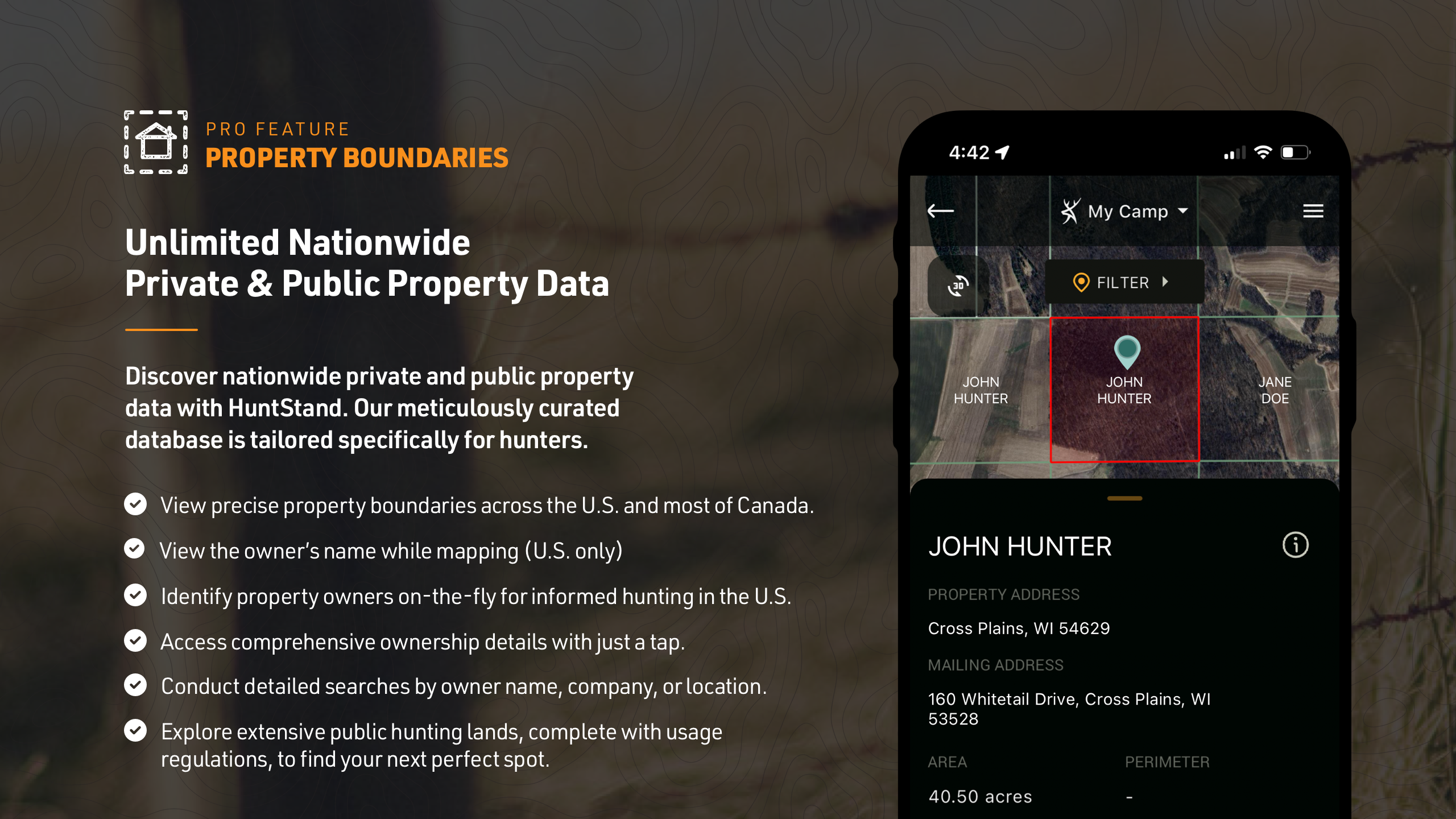
◆ Nationwide Property Lines: Access private and public property borders along with curated public land maps for all 50 states and most of Canada.
◆ Advanced Whitetail Forecasts: Get an exclusive 15-Day Whitetail Activity Forecast tailored to your precise location for optimal hunting times.
◆ Monthly Satellite Imagery: Monitor changes in your hunting grounds through monthly satellite images, including a historical archive spanning several years.
◆ Group Hunt Areas: Easily share hunting locations with friends, lease partners, and family members.
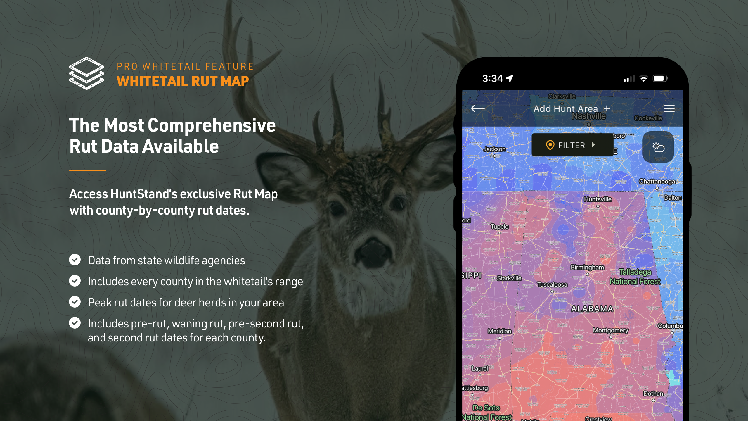
◆ Nationwide Rut Map: Gain insights from the county-level whitetail rut map, showcasing rut dates organized by phase using a color-coded system.
► Get Started with Free Mapping ►
Download HuntStand to commence mapping your hunting sites at no cost. Explore the essential features that make HuntStand a valuable tool for hunters.
◆ GPS Mapping: Track your position on the map, trace your movement, and save important locations like tree stands with map markers.
◆ HuntZone Wind Forecasting: Plan your hunts better with HuntZone, which offers hour-by-hour scent predictions up to 72 hours in advance.
◆ Hunt Area Customization: Tailor detailed maps of your hunting areas to meet your specific needs and easily share them with others.
◆ High-Resolution Satellite: Utilize high-resolution satellite imagery to precisely plan and navigate your hunting areas.
◆ Digital Rangefinder: Calculate distances effortlessly with the new rangefinder mode.
► HuntStand Pro Subscription ►
For just $29.99 per year, access the most economical hunting app available. Enjoy all the features of the free HuntStand app and additional nationwide hunting maps and tools.
◆ Nationwide Property Lines: View detailed property line maps for all 50 states and most of Canada.
◆ Property Ownership Data: Access comprehensive ownership information for all 50 states and search for property owners by name.
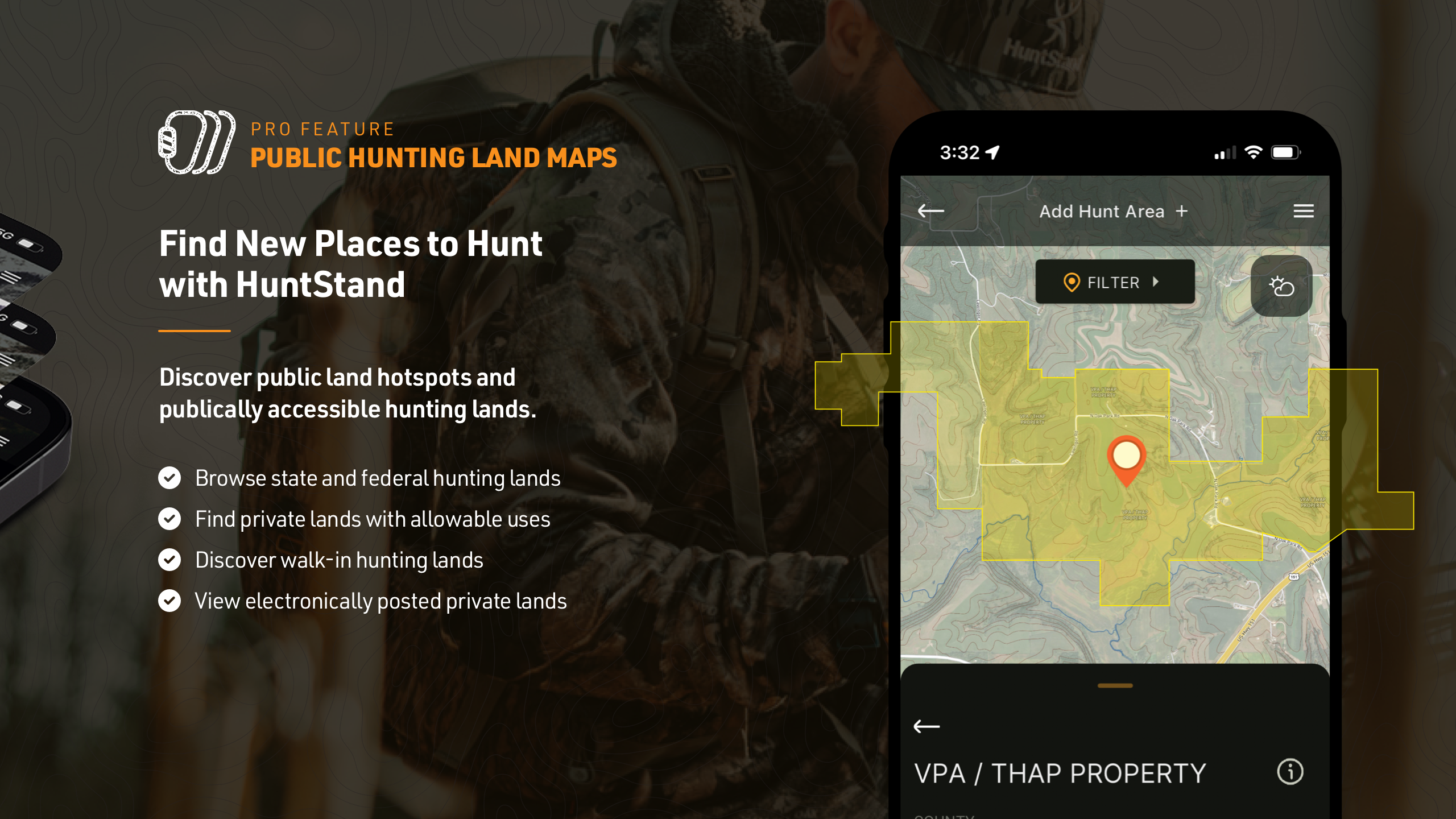
◆ Public Hunting Land Maps: Explore various public hunting lands to discover new hotspots.
◆ National Aerial Imagery: Access detailed aerial imagery for the entire U.S.
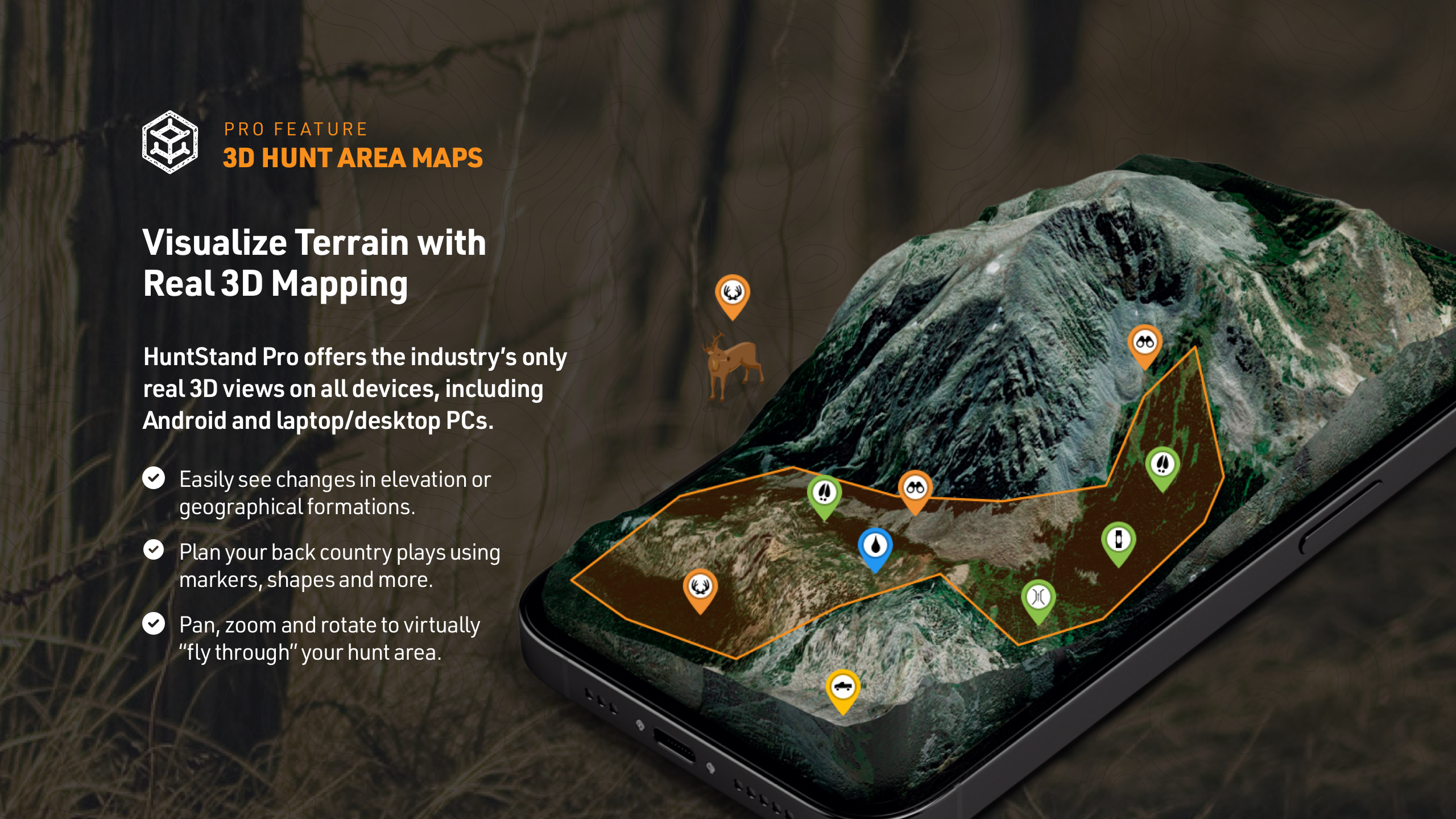
◆ 3D Mapping: Enhance your planning with dynamic 3D navigation of your hunting terrains.
◆ Unlimited Offline Maps: Save your hunting maps for offline use.
► HuntStand Pro Whitetail ►
Upgrade to HuntStand Pro Whitetail for an enhanced deer hunting experience. This subscription includes all features of HuntStand Pro plus specialized tools for whitetail hunters.
◆ All HuntStand Pro Maps: Access all HuntStand Pro maps.
◆ All HuntStand Pro Features and Tools: Utilize the full suite of HuntStand Pro functionalities.
◆ 15-Day Whitetail Activity Forecast: Predict deer movements accurately and identify peak hunting times.
◆ Annual Whitetail Rut Map: Visualize county-level rut data with rut dates presented for each phase.
◆ Whitetail Habitat Map: Identify prime deer habitats to discover new hunting areas easily.
Billing & Subscription: Charges are applied to your Google Play account upon purchase.
Tips for Users:
* Utilize GPS Mapping
View your current position on the map and trace your path as you move in real-time. Add map markers to save important locations like tree stands.
* Plan with HuntZone Wind Forecasting
Map out your scent impact with HuntZone, providing hour-by-hour scent predictions for up to 72 hours in advance.
* Customize Hunt Areas
Design detailed maps of your hunting areas, tailored to your specific needs, and share them with hunting buddies, lease partners, and family members.
* Use High-Resolution Satellite Imagery
View detailed, high-resolution satellite imagery of your hunting areas to plan and navigate with precision.
- Version6.8.2
- UpdateDec 08, 2024
- DeveloperGSM Outdoors
- CategorySports
- Requires AndroidAndroid 7.0+
- Downloads1M+
- Package Namecom.huntstand.core
- Signature3b84eb063cc209700a54eb72f93a9f6e
- Available on
- ReportFlag as inappropriate
-
NameSizeDownload
-
36.23 MB
-
36.22 MB
-
34.45 MB


Reliable, easy to use app
The weather & barometric pressure forecast is crucial
This is the worst app update I've ever experienced
Everything used to be so simple
The maps looked so clean