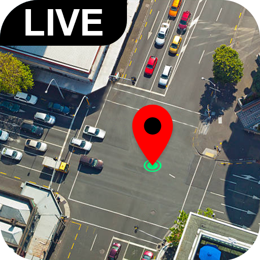
Street View Map and Navigation - Explore routes easily
Explore iconic streets and navigate with ease using interactive maps.
- 1.5.5 Version
- 1.4 Score
- 2M+ Downloads
- In-app purchases License
- 3+ Content Rating

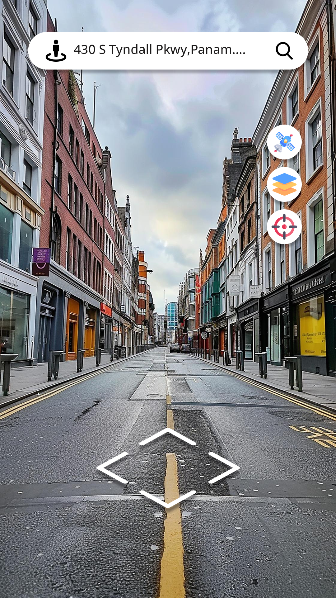
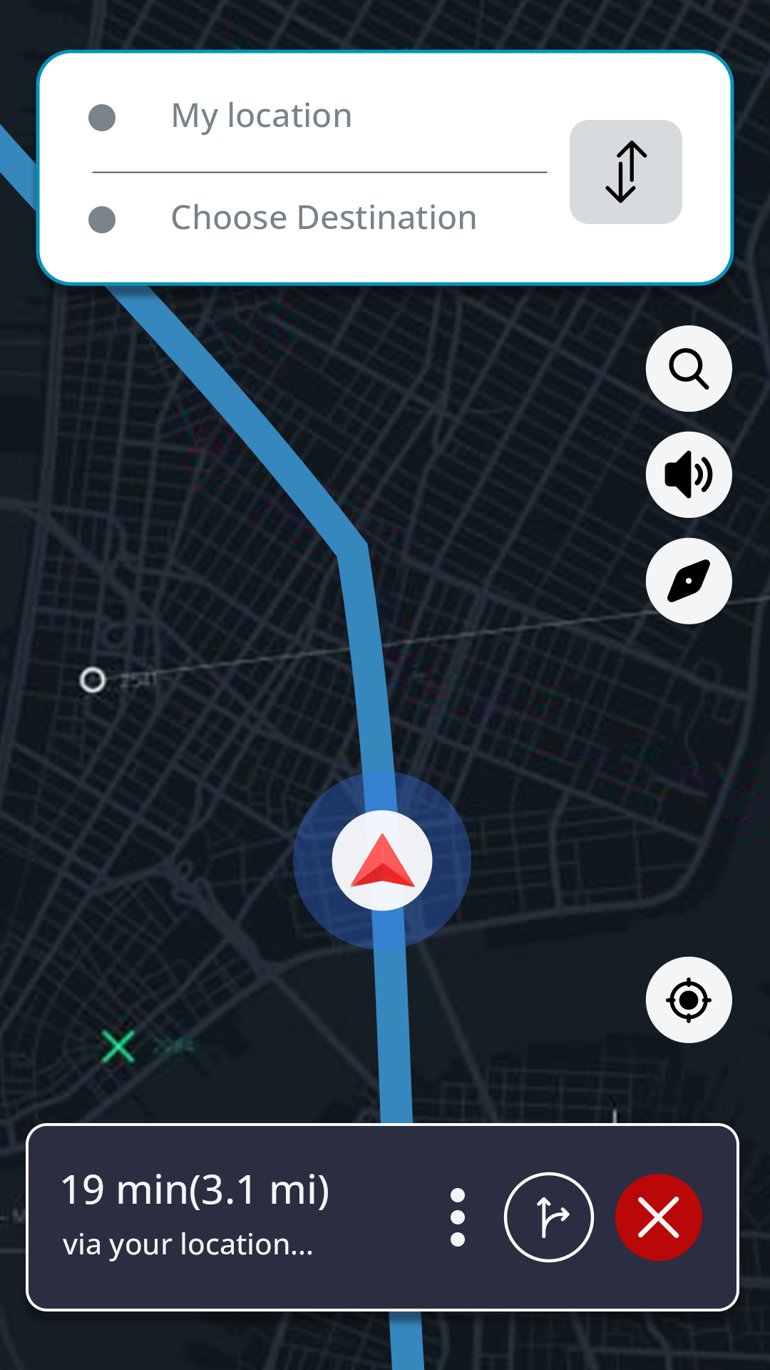

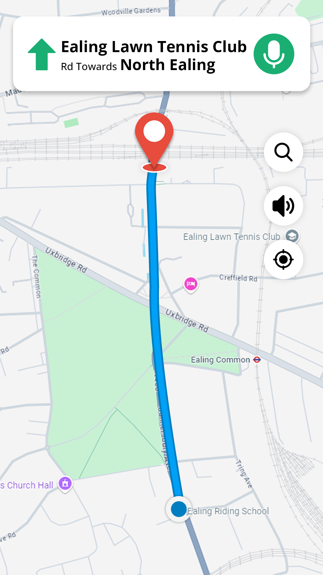
Introducing Street View Map and Navigation
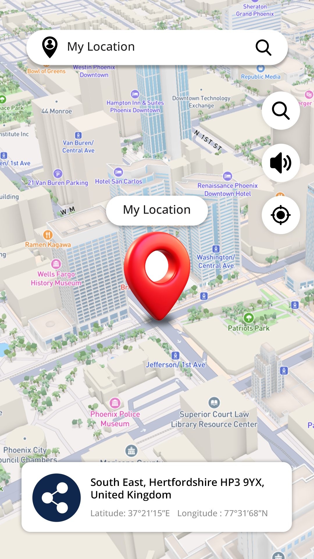
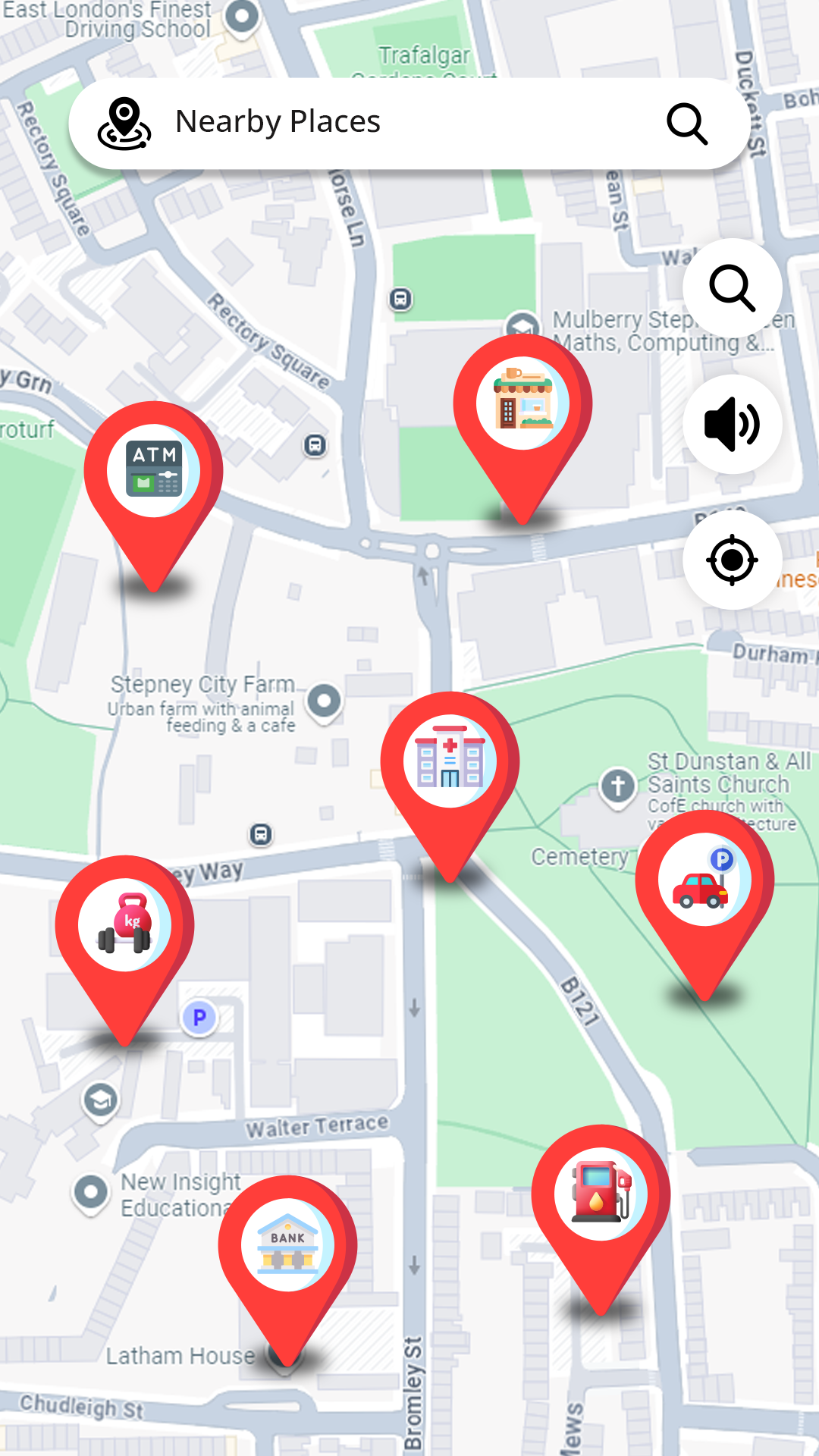
The Street View Map and Navigation app is a powerful tool designed to help users locate themselves at any given time or place. By utilizing satellite maps and GPS technology, users can access live street views, directions, and easily navigate their surroundings. The app also functions as a route finder, offering additional features such as area calculation, distance measurement, language translation, and more.
Key Features of Street View Map Navigation & GPS Route Finder:
- GPS Street View:
Explore different locations around the world with live street view maps, videos, and navigation assistance.
- GPS Navigation:
Real-time location tracking, satellite views, and voice-activated route planning for driving, walking, or cycling.
- GPS Route Finder:
Plan efficient routes for various modes of transportation, ensuring easy navigation and travel.
- Area Calculator:
Measure distances and calculate area sizes, ideal for farmers or daily route tracking.
- Translator:
Text and voice translation feature supporting multiple languages for seamless communication.
- Distance Finder:
Calculate distances between points on the map and get accurate navigator routes.
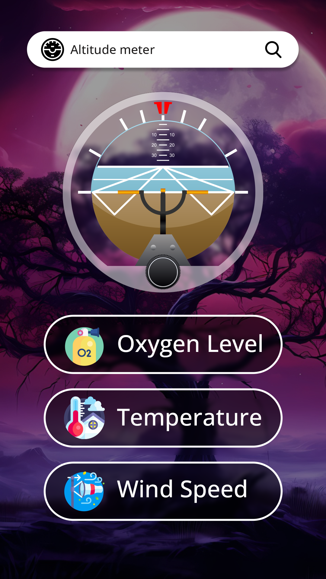
Additional Features:
- Save and share locations with others.
- Find altitude information in meters or feet using longitude and latitude coordinates.
Learn from 23 Google Maps Tricks You Need to Try
Google Maps is the Swiss Army Knife of apps, chock-full of navigation, geospatial-search, and customization tools. These tips and tricks will help you unlock its full potential.
By Chandra Steele
Updated April 28, 2024
 (Credit: Google)
Google Maps has changed how we navigate the world. Its desktop and mobile apps have become more than just a way to get from point A to B via car, public transportation, or on foot: The ubiquitous Google service is also a geospatial search engine for the world around us.
Google continues to revamp and improve its map product, but there are a ton of customizable tools and hidden functions already baked into Google Maps that you may not know about, such as Incognito Mode. Check out our tips for how to maximize your Google Maps power.
1. Unlock Your Directions
Instead of leaving Google Maps open while you go from point A to point B, you can see your route, ETA, and upcoming turns on your lockscreen with a feature called Glanceable Directions. To turn it on, open Google Maps, go to Settings, and choose Navigation on iOS or Navigation Settings on Android. Scroll down to find Glanceable Directions While Navigating and turn the slider on. As Lifehacker notes, they'll appear as system notifications on Android and Live Activities on iOS.
2. We're Doing It Live
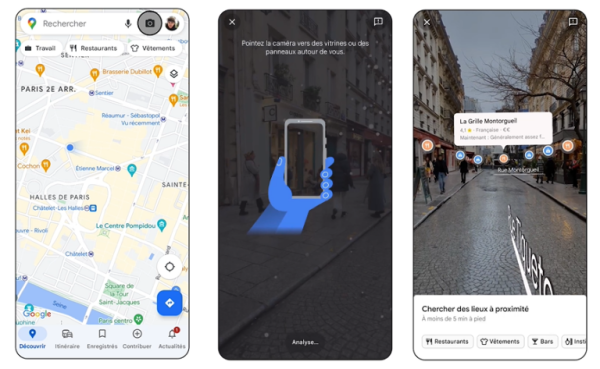
Search with Live View (Credit: Google)
You can get an AR view of the street you're on, if that street is in Amsterdam, Dublin, Florence, London, Los Angeles, New York, Paris, San Francisco, Tokyo, or Venice. Open Maps, click the camera icon at the top, and hold your phone up to scan your location. You'll get an overlay of all the places you'd see on Maps, so you can easily find restaurants, shops, and more.
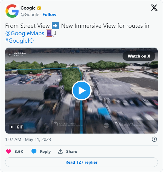
Meanwhile, Immersive View for routes, which rolled out in October, gives you a bird's-eye view of your route complete with 3D imagery along the way, whether you're walking, cycling, or driving. Look for it in select cities, including Amsterdam, London, New York, and Tokyo.
3. Inside Access
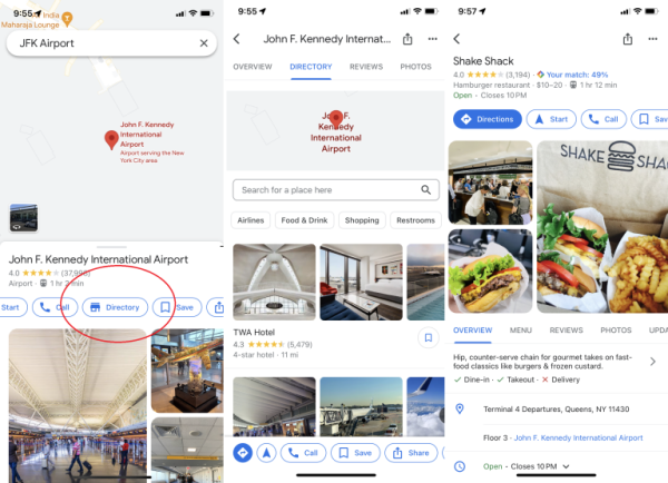
(Credit: Google/PCMag)
Google Maps isn't just for the great outdoors. You can navigate through malls, airports, and other big buildings by finding the location in Maps, clicking on it, then scrolling to Directory. You'll never get lost looking for a Cinnabon again. This feature is available in over 10,000 locations worldwide.
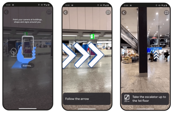
Navigating with indoor Live View (Credit: Google)
Some places even support Live View inside, where animated arrows will guide you around airports, train stations, and malls. It launched in 2021 in the US, Zurich, and Tokyo, and in early 2023, it announced plans to expand to more than 1,000 new locations in Barcelona, Berlin, Frankfurt, London, Madrid, Melbourne, Paris, Prague, São Paulo, Singapore, Sydney, and Taipei. Just lift your phone up in a supported region to jump into Live View.
4. Plot Multiple Locations on Google Maps
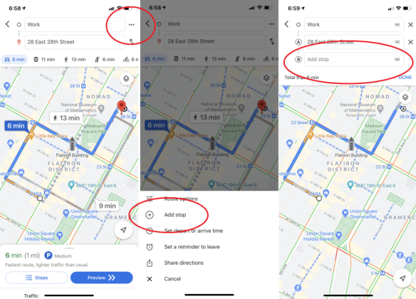
(Credit: Google/PCMag)
Rarely do car trips consist of going from point A to B; more often, they are something like A-to-café-to-library-to-Joe's-house-to-B. Thankfully, Google makes it possible to anticipate real trips. To add multiple destinations in the Google Maps mobile app, enter your starting point and your ultimate destination, and then click the three-dot menu in the top-right corner. This prompts a pop-over menu with the option to "Add stop." Click that, and you can create a route with multiple stops. You can even drag and drop stops within your itinerary. (Note that this doesn't work when you're using the mass-transit option.)
5. Customize Your Vehicle Icon
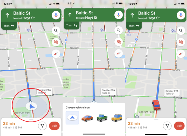
(Credit: Google/PCMag)
When you're driving, Google lets you choose what kind of car shows up on your navigation in the iOS and Android apps. In the app, plug in your destination and start up driving directions. Tap the icon that shows your current location, and a pop-up menu appears with several car-icon options: a sedan, a pickup truck, or an SUV.
6. 'Hey Google, Where Am I Going?'
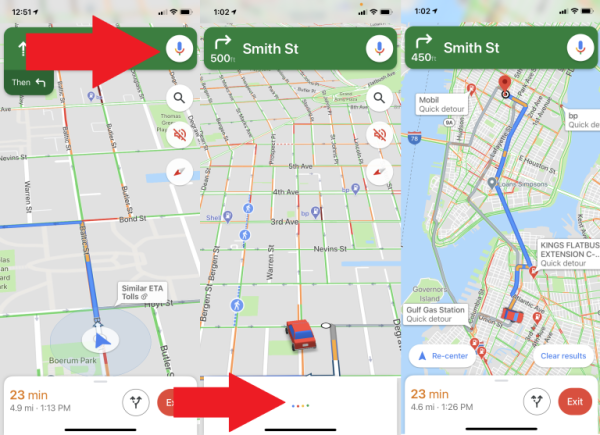
(Credit: Google/PCMag)
You might want to interact with Maps while you're driving, but you don't want to take your eyes off the road. With "OK Google" voice commands in the Google Maps Android app, you don't have to. For example, if you notice you're running low on gas, say "OK Google, find gas stations," and it will show gas stations on the map (which you can look at when you've come to a red light or pulled over). You can also ask questions like "What's my next turn?", "What's my ETA?", and "How's traffic ahead?" On Android, set up Google Assistant, and you're good to go. (You'll need a phone running Android Version 9.0 or higher with 4GB RAM or more.) On iOS (pictured above), tap the microphone icon at the top-right, then ask your questions via voice.
7. Access Google Maps Offline
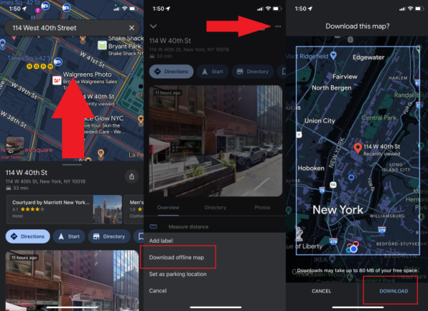
(Credit: Google/PCMag)
Today, Maps is most useful on mobile, which brings up a problem: When you're in need of Maps, you may find yourself somewhere with limited (or—gasp—nonexistent) coverage. To help, Google Maps supports offline access. Type in an address or area, swipe up on the menu at the bottom of the screen, tap the ellipsis icon on the top right, and select Download offline map. If you have enough storage on your device, the map in question will be saved. To access it later, tap your avatar > Offline maps, and you can then get information about businesses in the region and turn-by-turn directions within the downloaded section.
8. Get Your Groceries
(Credit: PCMag/Google)
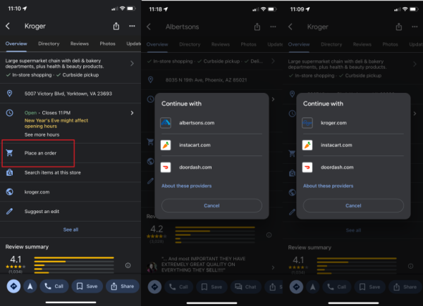
Google has incorporated grocery ordering and pickup functionality into Maps for select brands. Things kicked off a few years ago amid the boom in curbside pickup during the pandemic. That's still an option; in early 2023, Google touted the improvements it's made to the ETA function inside Google Maps for Kroger pickups. But grocery stores can also add a Place an order option to their Maps business profiles. In addition to Kroger stores (which also includes Fry's, Ralphs, and Marianos), it's also available for Albertson's and Fred Meyer locations.
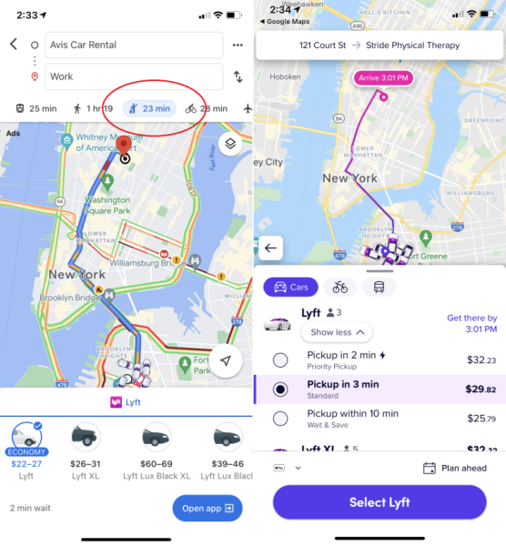
9. Let Other People Drive
(Credit: Google/PCMag)
Ride-sharing services are a big part of the modern transportation mix, so Google added ride options from companies such as Lyft (sorry, no more Uber) to its mobile app. Once you enter your destination, tap the little figure attempting to hail a taxi or the mass-transit option. You'll then be presented with nearby rideshare options, along with the estimated time of arrival and fare. Tap Open App to book your ride.
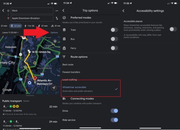
10. Find Accessible Transit Routes and Locations
(Credit: PCMag/Google)
Those with mobility issues can search for wheelchair-accessible transit routes by tapping Options > Wheelchair Accessible when looking for train or bus directions. When you get to your destination, meanwhile, the Accessible Places setting offers up wheelchair-accessibility information about that location.
Turn it on via Settings > Accessibility > Accessible Places. "When Accessible Places is switched on, a wheelchair icon will indicate an accessible entrance, and you’ll be able to see if a place has accessible seating, restrooms, or parking," Google says. "If it’s confirmed that a place does not have an accessible entrance, we’ll show that information on Maps as well."
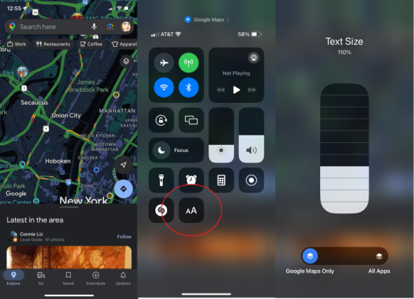
11. Change The Font Size
(Credit: PCMag/Google)
If the words on Google Maps are too small to read, make them bigger.
On an iPhone, make sure you have iOS 15 or higher via Settings > General > About. Then go to Settings > Control Center. Under More Controls, you'll see Text Size. Tap the green plus icon on the left, which moves it to the top under Included Controls. Now, open Google Maps and swipe down from the upper right where you see the battery icon. Tap on the Text Size button (an icon of a small A next to a large A). On the bottom, select whether you want to increase the font size on just Google Maps or across all apps. You can then increase the font size with the white bars. Close out of Control Center and your font adjustments should update automatically.
On an Android, you can change the size of the font or display but this is going to be a universal change across all of the device's apps. Open Settings, then select Accessibility. You can make words larger by tapping Font Size and then setting your preferred letter size or change the display size by tapping Display Size and then setting your preferred icon size.
12. Remember Where You Parked
(Credit: PCMag/Google)
Remember when the Seinfeld gang spent the whole half hour wandering around a parking garage looking for their parked car? That episode (along with many others) would not work in 2024, thanks to Google Maps.
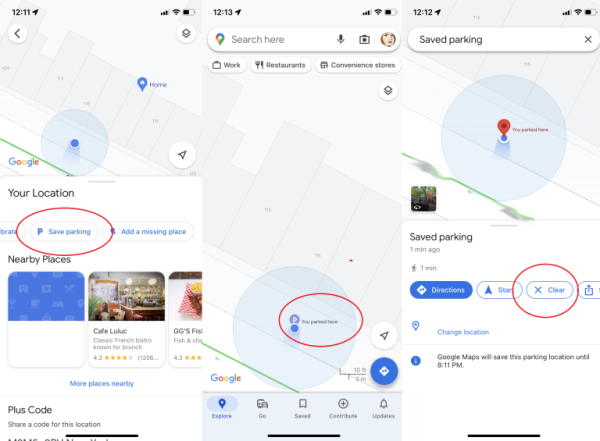
At your destination, tap the blue location dot, and select Save parking, which adds a label to the Maps app identifying where you parked. On Android, tap that to add details such as the parking garage level and spot or the amount of time left before a meter expires. You can also set meter reminders, add a photo of where you parked, and send your parking location to friends.
To find it later, tap the search bar at the top, and select Parking location (Android) or Saved parking (iOS). Or tap the Driving arrow below, and look for Saved parking on iOS. Google will automatically delete the parking reminder after 8 hours, though you can manually get rid of it by tapping You parked here on the map and selecting Clear (iOS) or More info > Clear (Android).
13. What's the Parking Sitch?
(Credit: PCMag/Google)
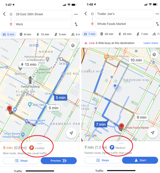
Google Maps can provide turn-by-turn directions based on live-ish traffic data, but it can also provide you with a glimpse of the parking situation. When you search for driving directions to a location on iOS or Android, you might see a P logo at the bottom of the screen along with one of three designations: limited, medium, and easy (plus On-site for retailers with large parking lots). This can help you decide how much time you'll need to allocate for parking or even whether another form of transportation would be a better option.
14. Share Your Location
(Credit: Google/PCMag)
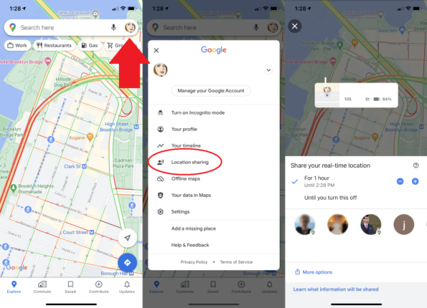
Google Maps lets you share your current location with people for specified periods of time. When you share your location with a certain contact, they'll see your icon moving in real time on their map. On mobile, tap your profile icon on the top right, and select Location sharing. Then choose with whom you want to share and for how long. (You may need to first allow notifications from Google Maps in your phone's settings menu.)
15. View (and Delete) Your Google Maps History
(Credit: Google/PCMag)
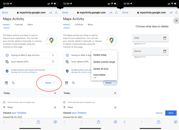
Google maintains a very detailed record of your digital activities. If you'd rather it lose your Maps data, you can erase it on desktop or mobile. On a desktop, go to maps.google.com. Click the hamburger menu, and select Your data in Maps. You'll end up on a page titled Google-wide Controls, where you can go to Location History > See & delete activity. You'll see a map with a timeline of your activity. On the bottom-right of the map, click the trashcan icon to delete all your location history permanently.
As of December 2023, the first time you turn on location history, Google will default you to auto-delete your history every three months. To adjust that, navigate to myactivity.google.com. Click Location History > Choose an auto-delete option, and choose how often Google will delete your data (every 3, 18, or 36 months) or turn auto-delete off completely.
On mobile, go to Settings > Maps History, which will bring you to a Maps Activity page. Look for the Delete drop-down menu, where you can opt to delete your history from today, all time, or a custom range. Tap Auto-delete to select a timeframe for when Google will automatically delete Maps data.
16. Go Incognito
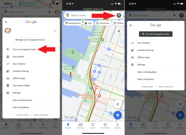
(Credit: Google/PCMag)
For a quick way to poke around Google Maps without leaving any obvious footprints, go Incognito. Google Maps won't save your browser or search history in your account or send notifications. Your searches and movements won't be added to location history or shared location. And Google won't use your activity while you're in Incognito Mode to personalize Maps. This mode has advantages when you want to peep a location without having it tangled up with your search history, but just as on web browsers, it doesn't make you invisible. To turn the mode on, tap your avatar and select Turn on Incognito mode; the Incognito icon appears in the search bar. Tap it and select Turn off Incognito mode to switch it off.
17. Time Travel With Google Maps
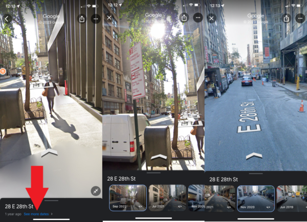
(Credit: PCMag/Google)
Street View has amassed a huge collection of street imagery over the years. In 2014, Google introduced Time Travel, a way for users to see how Street View has changed over time. And in 2022, it expanded from the desktop to mobile. To look back at a particular address, enter Street View and tap anywhere on the screen. At the bottom, tap See more dates. Where available, this should produce a series of photos. Scroll through and select the date you want to see.
18. Add Some Music
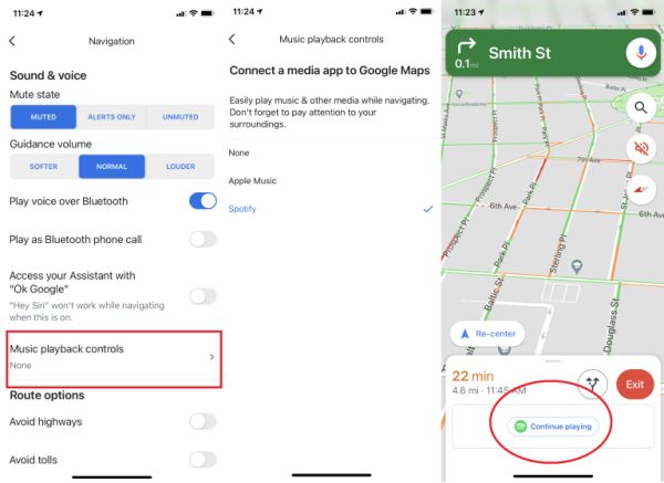
If you've always got Google Maps navigation open while you're driving (or walking), you can add music to your trip without leaving the app. Sync music apps such as Spotify or Apple Music by opening the menu and navigating to Settings. On iOS, tap Navigation > Music playback controls to connect Apple Music or Spotify. On Android, tap Navigation settings > Assistant default media provider, where you can link a number of music-streaming services, including YouTube Music, Spotify, Apple Music, iHeartRadio, Pandora, and Deezer. Once you do, a pop-up to your app of choice should appear as you're driving for a quick tap to get your music started. Be sure to create your playlists beforehand so you can keep your eyes on the road!
19. Find Electric-Vehicle Charging Stations
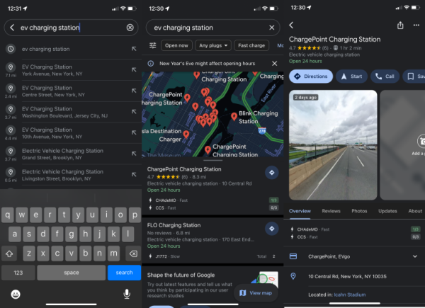
(Credit: PCMag/Google)
More and more electric vehicles (EVs) are taking to the road, and Google Maps is adapting. You can search "EV charging" or "EV charging station" in Google Maps, and it suggests the best station for you based on traffic conditions, your charge level, and the expected energy consumption. You can filter by types of plugs, and if you're in a rush, you can select Fast Charge to find the charging stations with the most voltage. If you use Android Auto in an EV, meanwhile, it will no longer show gas stations. If you're EV charger is housed in a hard-to-find location, like a parking garage, Google Maps will soon tap AI to help you find them faster.
20. Request Fuel-Efficient Routes
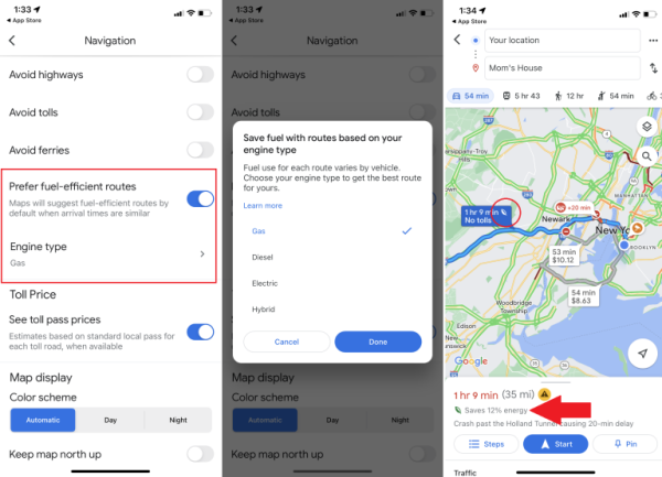
(Credit: Google/PCMag)
Want to make sure that next road trip is fuel-efficient? Turn on this setting in Google Maps and the app will prioritize fuel- or energy-efficiency over other factors like real-time traffic and road conditions. "So besides showing you the fastest route, it will also show you the most efficient one, even if they aren't the same," Google says.
Go to Settings > Navigation / Navigation settings and toggle Prefer fuel-efficient routes to on. Here, you can also tell Google Maps your engine type: gas, diesel, electric, or hybrid. Google will then serve up routes based on that engine type to help you save fuel.
21. Find Safe Drug-Disposal Locations
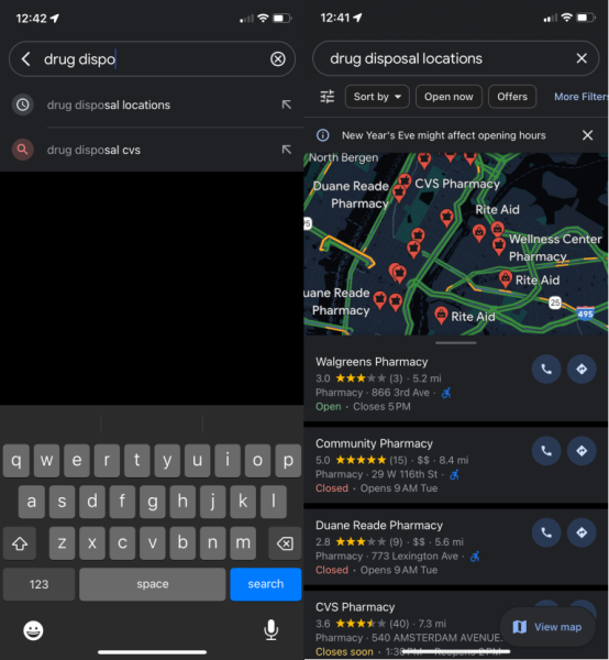
(Credit: PCMag/Google)
Google Maps is doing its part to fight the opioid crisis with a search tool to help users find safe drug-disposal locations. Type "drug disposal" into the search bar to pull up pharmacies, medical centers, and local authority locations where you can safely dispose of excess pills.
22. Share Your Favorite Places
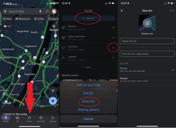
(Credit: PCMag/Google)
Google Maps lets you share some of your favorite places with a friend. Just tap the share icon on the location's Google Maps card to send it to them via text, email, or your app of choice. Save favorite places by tapping the Save icon; they then show up in the Saved option in the menu bar.
If you want to share more than one favorite location, you can create a Pinterest-like list within Google Maps. When you save a favorite place, tap New List to create a collection (like "Thai restaurants in Brooklyn") or add it to an existing collection. You'll find them in the Saved tab under Your lists; tap the three-dot menu and then Share List to send a link to friends.
23. Become (or Consult) a Local Guide
Think you know your neighborhood better than Google's algorithm? Then consider becoming a Local Guide. Although anyone can leave reviews and tips in Google Maps, being a Local Guides allows you to earn points for leaving more insights and data, which—as you go up the ladder—can result in "rewards and early access to new features," Google says.
- Version1.5.5
- UpdateSep 08, 2024
- DeveloperGPS Apps Box
- CategoryMaps & Navigation
- Requires AndroidAndroid 7.0+
- Downloads2M+
- Package Namecom.gps.maps.navigation.webcam.translator
- Signaturef0a445d167349b62e6d386975a486b47
- Available on
- ReportFlag as inappropriate
-
NameSizeDownload
-
18.05 MB
-
42.10 MB
-
39.24 MB


Easy to use
great features
needs updated some streets
very very slow